Another Stormy Week Ahead For California

(Photo: California Department of Transportation)
California is facing another week of heavy rain and snow after a major storm just hit the state last week. Several more feet of snow fell in the Sierra Nevada to end the month of February, closing sections of I-80 and other routes often used by truckers hauling loads from Nevada and Utah into northern California. Relentless downpours flooded areas just north of San Francisco, where homes and businesses were almost underwater. It remains to be seen how bad the coming storm will be, but it's fair to say that it may cause more damage and travel problems.
Snowbound

Another powerful low pressure system is about to slam into the Golden State on Tuesday, dumping more snow in the Sierra Nevada for a few days. This is on top of record February snowfall reported by many ski resort owners, and snow depth across the region that far exceeds what is was a year ago.
Snow levels will start at 5,000 to 6,000 feet and higher on Tuesday, dropping to 3,500 to 4,500 feet by Thursday as colder air filters into the lower slopes. Some areas will get slammed with several more feet of snow, depending on location and elevation. Accumulations of up to four feet are possible on the western slopes of the northern Sierra from Tuesday evening through Thursday morning. This includes I-80 over Donner Pass, and US-50 over Echo Summit.
Pockets of five-foot snow totals could bury areas of western Plumas County and Lassen Volcanic National Park. Two feet or more could also fall from Yosemite National Park to Kings Canyon National Park, as well as in places like Aspendell and Whitney Portal in the eastern slopes.
Up to three feet of snowfall in the high elevations around the Reno-Carson City metro areas will make travel difficult on I-80 heading into eastern California. This includes the cities of Bridgeport,
Coleville, Incline Village, Mammoth Lakes, South Lake Tahoe, Stateline and Truckee.
Meanwhile, the high terrain of Siskiyou County, along the Oregon border, may get spared from the heaviest snowfall, with totals of 10 to 20 inches likely. However, a few inches of snow may impact drivers on I-5 north of Redding.
Blowing snow and limited visibility will also be issues as wind gusts in some portions of the Sierra reach 60 mph. Winter Storm Watches have been issued by the National Weather Service (NWS) and may be upgraded to the more serious Winter Storm Warnings as the storm evolves. Look for official updated alerts on this interactive map.
Flood Threat
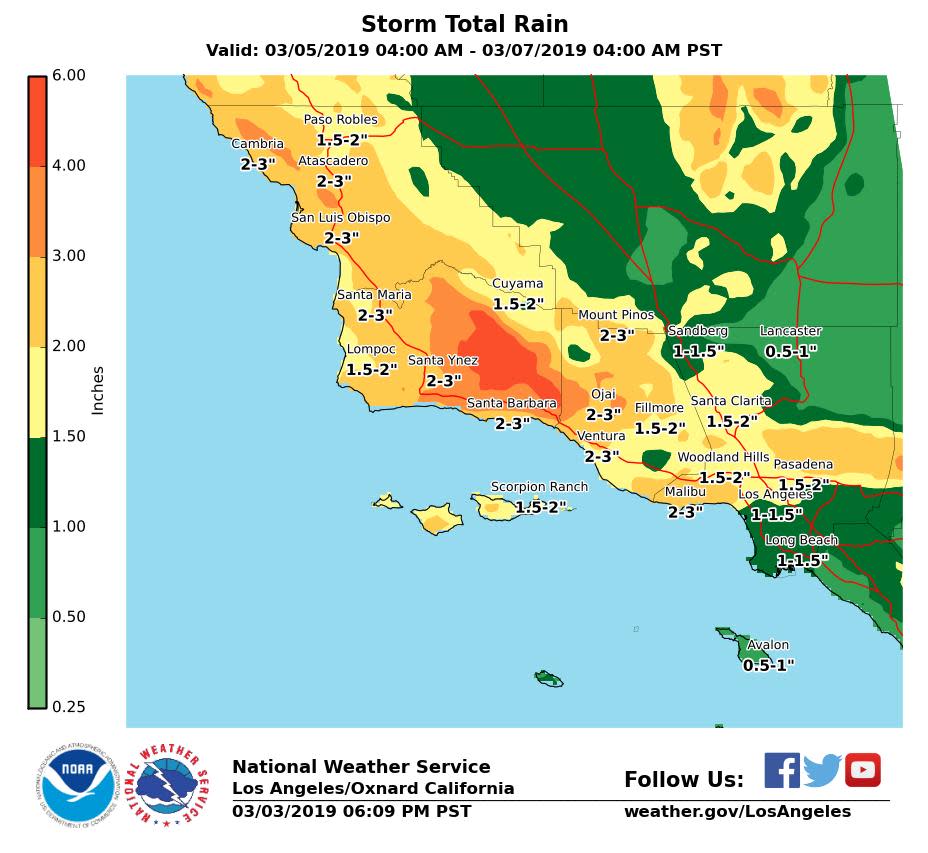
The San Francisco metro area may get spared from flooding this time around, but the foothills of the Central Valley could get waterlogged with up to two inches from Redding to Fresno to Bakersfield. Heavier amounts are likely in and near coastal areas from San Luis Obispo to the Los Angeles metro area. Totals of two to three inches of rainfall will be common, with four to six inches in the mountains. Occasional thunderstorms will produce torrential downpours.
Besides possible flooding of urban areas and low lying neighborhoods, there's also the potential for mudslides and rock slides blocking canyon roads. Drivers should expect delays on US-101, the Pacific Coast Highway and possibly I-5.
Please be careful out there, and Look for weather updates throughout the week on the FreightWaves website!
Want more content like this? Click here to Subscribe
See more from Benzinga
© 2019 Benzinga.com. Benzinga does not provide investment advice. All rights reserved.
