'Historical Google Earth’ showing lost British landscapes created by Cambridge University
Few people will remember the ‘Cornish Alps’ which once dominated the skyline around St Austell. After the Aberfan disaster of 1969, when the colliery spoil tip slid onto the Welsh village killing 144 people, the huge waste mounds from the England’s china clay industry were levelled, changing the terrain forever.
But a new project by Cambridge University, dubbed ‘historical Google Earth’ is allowing a glimpse back into the lost scenery of Britain, awakening long-forgotten landscapes.
The first 1,500 photographs from a vast archive of almost half a million aerial images have been digitised and put online, opening a window into the past to when Second World War bomb-damage still blighted city streets and motorways began to carve up the countryside.
The images were originally commissioned by Cambridge’s Committee for Aerial Photography, who spent decades sending up former RAF pilots to map the changing face of the UK.
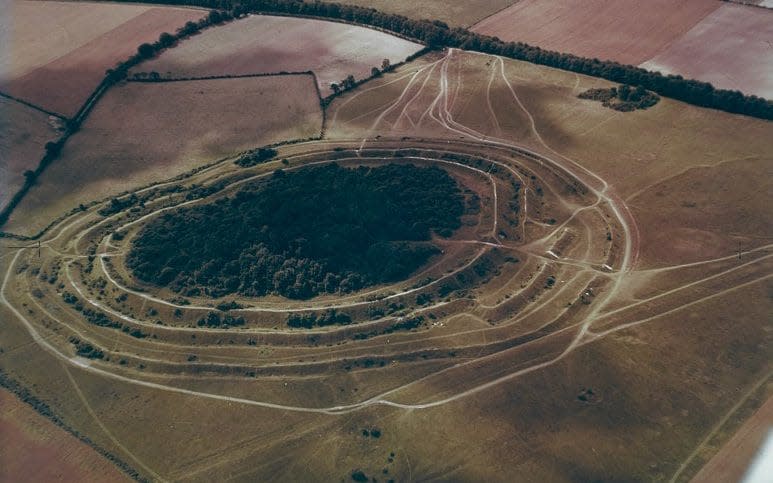
Alongside Cornwall’s clay mountains, the images show Neolithic henge monuments, long since destroyed by development, and poignant reminders of Britain’s world-class shipping industry, such as The Millwall Docks which closed in 1980.

Oxford academic, Dr Robert Bewley, a world authority on aerial archaeology, said a photograph of a lost prehistoric henge monument in Dorchester was the standout image for him.
“It represents a very important site that was totally destroyed by gravel extraction so these photographs are the only record of the site in its landscape context,” he said.
“Destruction of sites like this led to an acceleration of aerial reconnaissance in the UK and then Europe, so it’s a great example of the pioneering work down by the founder of the archive, Professor JK St Joseph.”
St Joseph became a pioneer of air archaeology after his work analysing RAF reconnaissance photos during World War Two and came to realise there was a huge opportunity to use similar photos in archaeology and geology.

The photographs, span almost all of Britain, capture the loss of our industrial heritage, the destruction of ridge and furrow landscapes unchanged for centuries, and the emergence of skyscrapers and modern cityscapes.
Cambridge archaeologist Professor Martin Millett, who has frequently used the original photography in his own research, said: “Anyone can go to Google Earth and look at modern satellite imagery – but this is an historical Google Earth that lets you travel back through time to a Britain which no longer exists.
“In this first batch of photos, including some very early colour photography, we have cherry-picked some of the best and most beautiful images documenting the changing face of cities, towns and coastlines from all over the UK.
“Cambridge aerial photography was pioneering and unique. No-one else in the world was doing this - it was genuinely world-leading. The Digital Library, it’s a vital and fascinating window into the past.”

The earliest photographs, numbering in the hundreds, date back to 1945 – but the project took off in earnest in 1947 when, over the course of the year, more than 2,000 aerial images were captured.
The Committee continued to borrow RAF planes and pilots until the University bought its own Cessna Skymaster in 1965.
The Cessna, based at Cambridge Airport, travelled the length and breadth of Britain and helped to capture high resolution archaeological detail from the air; transforming our understanding of UK history over millennia, including medieval England, the Roman occupation of Britain and prehistory.
The Department of Geography and Cambridge University Library are now exploring potential plans to digitise the remaining hundreds of thousands of photographs and negatives in the Aerial Photography archive.
Professor Tom Spencer, who specialises in coastal research at Cambridge and has used the archive extensively, said: “We are serious about digitising the entire collection. St Joseph had a vision and this archive is his legacy – we are doing all we can to preserve it and make it available for the next generation.”
The first 1,500 images can be found here.
Sign up for your essential, twice-daily briefing from The Telegraph with our free Front Page newsletter.
