Ian crashes into Sarasota-Manatee region and into the history books
Hurricane Ian crashed into Southwest Florida Wednesday and into the history books as one of the worst storms to hit the area in modern times, bringing massive storm surge, incredible amounts of rain and some of the strongest winds of any hurricane to impact Florida.
Ian surged to a near Category 5 hurricane — the highest wind category — early Wednesday with 155 mph sustained winds.
The storm made landfall at 3:05 p.m. near the island of Cayo Costa with maximum sustained winds of 150 mph. Maximum winds dropped to 140 mph by 5 p.m., 115 mph by 8 p.m. and 90 mph by 11 p.m. as the hurricane moved inland.
Videos broadcast on television and shared on social media showed devastating storm surge flooding in areas around Fort Myers and Naples by early Wednesday afternoon, with buildings and cars submerged in water. Fort Myers Beach and Sanibel island were among the communities inundated with surge water.
Extensive wind damage also is certain near where the storm made landfall, and inland flooding from heavy rains is expected to be widespread around the state.
Gov. Ron DeSantis predicted that the scope of the damage will require “really an unprecedented effort in the history of the state” to get impacted regions recovered.
Live Updates: Gov. Ron DeSantis will update Floridians on ferocious Hurricane Ian
Storm update: Hurricane Ian grows into powerful Category 4 storm. Maximum sustained winds up to 155 mph
Where is Hurricane Ian right now?: See NWS radar showing storm's movement near Sarasota, Florida
Power outage map: See Sarasota-Manatee power outage map as Hurricane Ian impacts Florida
"Clearly this a very powerful, major hurricane that's going to have major impacts," DeSantis said during a news conference early Wednesday. "Both impact in Southwest Florida but then as it continues to work through the state it's going to have major, major impacts."
Ian's eyewall began coming ashore late Wednesday morning. Radar images showed the large eyewall extending all the way from Sanibel up to the Cape Haze peninsula.
The worst hurricane damage occurs around where the eye makes landfall, but the impacts from the storm will be far and wide, stretching across the entire Florida peninsula. The storm was expected to travel up the center of the state, passing over the Orlando area and exiting south of Jacksonville, a trail of devastation that could leave deep wounds.
“This is going to be a rough stretch," DeSantis said. "We’re here to respond to the areas that are impacted once the storm is past."
Communities that initially were forecast to bear the brunt of Ian may be spared some of the worst impacts, with the storm passing well south of the Tampa Bay region.
Manatee County also avoided a direct hit, and much of Sarasota County seemed likely to as well, but both still experienced strong winds, heavy rain and significant storm surge, with southern Sarasota County and North Port likely to see the most significant local damage.
Venice resident Frankie Abbruzzino, a candidate for mayor, posted a video on Facebook around 5 p.m. of flooding in his home. The video also shows his pool cage screen, which was blown away by Ian's winds and lay in pieces on his property. The City of Venice posted a photo on Twitter around 9 p.m. showing significant damage to Venice Theatre downtown.
Damage to Venice Theatre pic.twitter.com/46RdUCmV64
— City of Venice, FL (@CityofVeniceFL) September 29, 2022
Among the earliest signs of Ian's damage: A reporter with Fox 35 out of Orlando posted a photo on social media of Sarasota Jungle Garden's sign crumpled to the ground along Tamiami Trail Wednesday morning.
Sarasota County put out an alert shortly after 1 p.m. Wednesday that winds had reached 45 mph and emergency vehicles no longer were responding. Much higher wind gusts were reported throughout the region by late afternoon. Sarasota Memorial Hospital went into lockdown shortly before 1:30 p.m..
The “TURN HERE” sign for Sarasota Jungle Gardens tourist attraction has toppled along the Tamiami Trail. #HurricaneIan pic.twitter.com/BJxbuZpzVn
— David Martin FOX 35 (@FOX35David) September 28, 2022
Even with Ian passing to the south, the National Hurricane Center said all of Sarasota and Manatee counties had a high probability of experiencing hurricane-force winds of 74 mph or greater. Significant storm surge of between 4 to 10 feet also was forecast for the Sarasota and Manatee coastlines.
A NHC advisory released Wednesday morning predicted "catastrophic storm surge" of 12 to 18 feet from Englewood to Bonita Beach. Videos of the storm surge in that region showed water flowing down streets and between buildings. Naples Fire-Rescue Department posted a Facebook video of a fire station and fire trucks submerged in water.
Lee County Manager Roger Desjarlais said during an evening news conference that "we are beginning to get a sense that our community has been, in some respects, decimated. "
Ian bore striking similarities to Hurricane Charley, which leveled Punta Gorda in 2004. Charley also was initially forecast to make landfall farther north before taking a sharp turn east and traveling up Charlotte Harbor.
Yet while Charley was a very powerful storm, it was a very small one and the worst damage was confined to a relatively narrow area. Ian is dramatically larger, and will scar a much wider part of the state. All of Charley fits into Ian's eye, according to Weather Channel correspondent Justin Michaels.

The National Hurricane Center predicted "catastrophic wind damage" in parts of Southwest Florida as Ian came ashore near rare Category 5 strength. A Category 5 storm has wind speeds of 157 mph or greater.
Additionally, "heavy rainfall will spread across the Florida peninsula through Thursday" with significant flooding expected well inland, according to the NHC.
Up to 15 inches of rain was forecast for Manatee County, much of Sarasota County and a vast swath of Florida extending up through Orlando and Jacksonville. Some parts of the state could see up to 20 inches of rain in a short period, creating dangerous flood conditions.
The National Weather Service's Ruskin office said communities across Southwest Florida already had seen between 5 to 16 inches of rain by 6:30 p.m. Wednesday, and another 3 to 6 inches was possible.
Evacuation efforts were continuing in parts of Florida Wednesday morning, but much of the state was hunkered down and bracing for Ian's impacts.
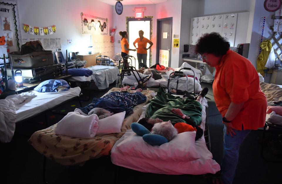
Officials in Sarasota and Manatee counties said Wednesday that the shelters set up to house those who had to evacuate their homes were only at a fraction of capacity.
Sarasota County spokeswoman Brianne Grant said shelters can accommodate about 26,000 people, but there were only about 2,600 people in the county’s 12 shelters at 8:30 a.m. and about 4,000 shortly before 1 p.m..
In Manatee, there were 2,528 people in 17 shelters early Wednesday morning, and the county can handle about 27,000, a county official said. The number of people in shelters doubled to about 5,000 by mid-morning as a surge of people sought safety before the shelter doors were locked shortly after 10 a.m..
Florida Power & Light reported roughly 1 million customers without power across Florida as of 9:45 p.m. Wednesday, including 254,660 in Sarasota County and 129,890 in Manatee County. Nearly 89% of FPL's customers in Sarasota and 65% in Manatee were without power.
Power went out at Sarasota County's storm shelters, other than the two special needs shelters powered by generators.
Manatee County Administrator Scott Hopes warned about significant flooding from Ian's downpours, and said people should wait to move about after the storm until the county gives the all clear, noting there could be a lot of standing water. About 100,000 Manatee residents were ordered to evacuate. Those remaining were told to shelter in place Wednesday morning.
“Just because the weather clears and the skies blue doesn’t mean it’s necessarily safe to go out and about,” Hopes said.
DeSantis also warned people to be careful after Ian passes.
"Make sure to avoid downed power lines, avoid standing water, stay clear of trees, do not drive in standing water and keep generators 20 feet outside of your home," the governor tweeted late Wednesday.
A Category 4 or 5 hurricane has hit Florida 14 times since record-keeping began, the most recent being Michael in 2018 and Irma in 2017, according to Colorado State University meteorologist Phil Klotzbach. The last one to make landfall in Southwest Florida was Charley.
Herald-Tribune staff writers Anne Snabes, Gabriela Szymanowska, Jesse Mendoza and Melissa Perez-Carrillo contributed to this report. Follow Herald-Tribune Political Editor Zac Anderson on Twitter at @zacjanderson. He can be reached at zac.anderson@heraldtribune.com
This article originally appeared on Sarasota Herald-Tribune: Hurricane Ian causes damage in Sarasota and Manatee counties
