Mineralized drill intercept summary for drill holes completed at the CV13 Cluster in 2022
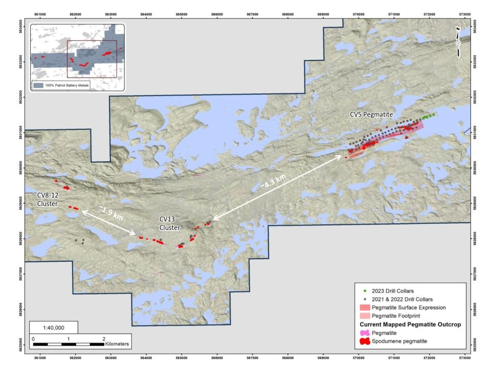
Figure 1.
Location of the CV13 Cluster
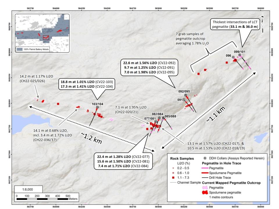
Figure 2.
Surface and drill hole exploration summary for work completed in 2022 at the CV13 Cluster
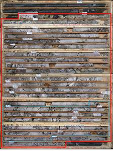
Figure 3
Spodumene drill-core intersection in drill hole CV22-092 (22.6 m at 1.56% Li2O, including 6.0 m at 3.19% Li2O)
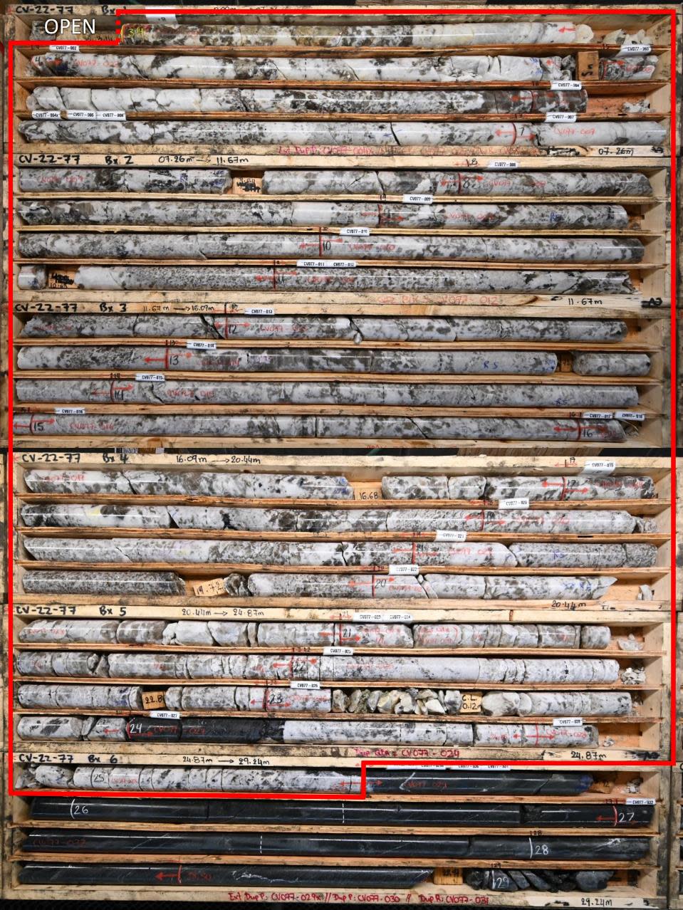
Figure 4
Spodumene drill-core intersection in drill hole CV22-077 (22.4 m at 1.28% Li2O), which collared in spodumene pegmatite.
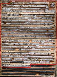
Figure 5
Spodumene drill-core intersection in ‘lower’ pegmatite, drill hole CV22-085 (8.1 m at 0.98% Li2O)
Figure 6
Spodumene mineralization from various drill holes completed at the CV13 Cluster in 2022.
VANCOUVER, British Columbia and SYDNEY, Australia, Feb. 13, 2023 (GLOBE NEWSWIRE) --
Highlights
Significant intervals of spodumene pegmatite intersected near-surface in ten (10) of fourteen (14) drill holes to test the newly discovered CV13 Pegmatite Cluster.
22.6 m at 1.56% Li2O (29.3 m to 51.9 m), including 6.0 m at 3.19% Li2O (CV22-092).
22.4 m at 1.28% Li2O (3.1 m to 25.5 m) (CV22-077) – collared in lithium pegmatite.
15.6 m at 1.50% Li2O (2.8 m to 18.3 m) (CV22-081) – collared in lithium pegmatite.
18.8 m at 1.01% Li2O (23.8 m to 42.6 m), including 4.0 m at 2.37% Li2O (CV22-103).
17.3 m at 1.41% Li2O (20.6 m to 37.9 m), including 8.0 m at 2.09% Li2O (CV22-104).
Second spodumene pegmatite intersected at depth, returning 8.1 m at 0.98% Li2O (167.4 m to 175.4 m) (CV22-085).
Three (3) of four (4) areas initially tested along the combined 2.3 km trend returned strong lithium mineralization, including all six (6) drill holes targeting the area of the main spodumene outcrop at the apex of a regional flexure.
Majority of the trend remains to be drill tested.
Drill results supported by surface channel sampling of mineralized outcrops, with results including:
14.2 m at 1.17% Li2O (CH22-025/026)
13.1 m at 1.57% Li2O (CH22-017)
Company evaluating infill and step out drilling during the current winter program to support an initial mineral resource estimate at CV13 scheduled for 2023.
Darren L. Smith, the Company’s Vice President of Exploration, comments: “The results from the first pass drill testing at CV13 are very positive with ten (10) of our first fourteen (14) drill holes along this collective 2.3 km trend returning strong lithium mineralization. The CV13 Pegmatite cluster is a grassroots discovery from summer 2022 and to advance over several months to an intersection of 22.6 m at 1.56% Li2O in our first series of drill holes is an impressive feat and highlights again the magnitude of the mineralized system(s) and continued potential for new discoveries at the Corvette Property.”
Patriot Battery Metals Inc. (the “Company” or “Patriot”) (TSX-V: PMET) (ASX: PMT) (OTCQX: PMETF) (FSE: R9GA) is pleased to announce assay results from its 2022 drill and surface exploration programs over the CV13 Pegmatite cluster at its wholly owned Corvette Property (the “Property”), located in the James Bay Region of Quebec. The CV13 Pegmatite cluster, which is comprised of two contiguous lithium outcrop trends totalling 2.3 km in combined strike length, is located approximately 4.3 km along geological trend to the southwest of the CV5 Pegmatite (Figure 1).
A total of fourteen (14) drill holes (NQ core size – 47.6 mm inside diameter), totalling 2647 m, were completed at CV13 in 2022 – the first drill program ever completed at the target. A total of six (6) holes were completed at the confluence of the two trends (CV22-077, 081, 082, 084, 085, and 088), two (2) holes along the western limb of the trend (CV22-103 and 104), and six (6) holes along the eastern limb of the trend (CV22-091, 092, 095, 096, 099, and 101) (Figure 2). Of these fourteen (14) drill holes, ten (10) returned well-mineralized intervals of lithium pegmatite over three distinct areas of the collective trend (Figure 2). Drill core assays highlights include 22.6 m at 1.56% Li2O (29.3 m to 51.9 m), including 6.0 m at 3.19% Li2O (CV22-092 – east limb), 22.4 m at 1.28% Li2O (3.1 m to 25.5 m) (CV22-077 – confluence of trends), which collared in lithium pegmatite, and 17.3 m at 1.41% Li2O (20.6 m to 37.9 m), including 8.0 m at 2.09% Li2O (CV22-104 – west limb).
The potential of the CV13 Cluster is further supported by outcrop grab sampling (see news release dated August 10th, 2022) as well as outcrop channel sampling completed in the fall of 2022, with results including 14.2 m at 1.17% Li2O (CH22-025/026), 13.1 m at 1.57% Li2O (CH22-017), and 10.5 m at 1.53% Li2O (CH22-018/19) (Figure 2). Channel CH22-025/026 is located approximately 600 m along trend to the northwest of drill holes CV22-103 and 104 (18.8 m at 1.01% Li2O, and 17.3 m at 1.41% Li2O, respectively), and remains to be drill tested.
Based on the surface mapping and drilling completed to date, the CV13 Pegmatite cluster is characterized by two, shallow to moderately dipping, sub-parallel trending Li-Cs-Ta (“LCT”) pegmatite bodies, which have been intersected in multiple drill holes along the overall 2.3 km trend. The primary LCT pegmatite body (the ‘upper’ pegmatite) outcrops at surface and is interpreted to have been intersected near-surface in each of the fourteen (14) drill holes completed to date, testing four (4) distinct areas along the overall trend with results including 22.6 m at 1.56% Li2O (29.3 m to 51.9 m) (CV22-092 – east limb) and 22.4 m at 1.28% Li2O (3.1 m to 25.5 m) (CV22-077 – confluence of trends). This ‘upper’ pegmatite ranges generally from 6 m to 36 m in width (core length) and appears to have significant strike extent based on intersections in drill hole and pegmatite outcrop exposed discontinuously along the trend. A second LCT pegmatite (the ‘lower’ pegmatite) is also present at depth, being intersected in several drill holes which tested such depths, and is variably mineralized ranging from relatively low-grades over several metres to 8.1 m at 0.98% Li2O (167.4 m to 175.4 m) in drill hole CV22-085. Additional drilling is required to ascertain the relationship between the two bodies and if they may coalesce at some point into a larger body.
Based on geological logging and chemistry, the primary lithium mineral at CV13 is spodumene (Figure 6). The spodumene crystals are more variable in size compared to those typically observed at the CV5 Pegmatite located approximately 4.3 km along geological trend to the northeast. However, crystal sizes of the spodumene at CV13 still commonly range from approximately centimetre to decimetre in scale.
Drill holes CV22-096, 099, and 101, which targeted the northeast end of the eastern limb at CV13, intersected wide intervals of LCT pegmatite (14.9 m, 36.0 m, and 33.1 m, respectively), although, only returned anomalous lithium mineralization over these intervals. The highest lithium grades from each hole were 1.08%, 0.82%, and 0.58% Li2O in individual samples, respectively; however, each of the holes also returned significantly elevated levels of Cs (>1000 ppm), Rb (>1%), and Ta2O5 (>100 ppm, including a 5,784 ppm sample in drill hole CV22-096). Additionally, several lithium pegmatite outcrops in the immediate area returned an average 1.78% Li2O over seven (7) grab samples, confirming strong lithium mineralization proximal to these drill holes. As lithium pegmatites are commonly zoned, the drill core sample chemistry, coupled with the strong lithium mineralization in nearby outcrop, suggests a strong potential that higher grade lithium pegmatite may be proximal to that intersected in CV22-096, 099, and 101. Further, the Company is encouraged by the two (2) +30 m intersections of anomalous LCT pegmatite in two (2) of the three (3) drill holes (CV22-099 and 101), which are situated directly on geological trend and within 4.4 km of drill hole CV22-074 (16.9 m at 2.00% Li2O) at the CV5 Pegmatite.
The CV13 lithium pegmatite cluster is characterized by two (2) contiguous trends, totalling approximately 2.3 km in combined strike length (Figure 2). To date, the cluster is characterized by a total of thirty-one (31) spodumene-bearing (field identified as spodumene) outcrops, including twenty (22) outcrops with >5% visually estimated modal spodumene content. The two largest outcrops are approximately 70 m long by 12 m wide and 100 m long by 15 m wide, situated approximately 300 m apart.
The CV13 Cluster is interpreted to be part of a much larger LCT pegmatite system at the Property, potentially extending from the most easterly identified CV4 Cluster, and continuing westerly through the CV5 and CV8-12 clusters, a distance of approximately 15 km (Figure 1). The scale of LCT pegmatite present along this trend suggests a deeply rooted and common ‘plumbing’ system and source of the lithium mineralized bodies discovered to date. A significant portion of this trend remains to be drill tested and lithium mineralization confirmed, with the CV5 Pegmatite being the largest continuous mineralized body delineated to date at 2.6 km. It is situated approximately 4.3 km along geological trend to the northeast of the CV13 Cluster, along a corridor that remains to be drill tested. The CV8-12 Cluster is situated approximately 1.9 km to the northwest of the CV13 Cluster, also along a corridor that remains to be drill tested.
A majority of the CV13 Pegmatite trend remains to be drill tested. The strongest drill results from the inaugural 2022 drill program are focused proximal to the confluence of the regional flexure within the overall trend (Figure 2) – an area of potential dilation and therefore favourable setting for lithium pegmatite emplacement. This area of the trend is anticipated to be the focus of step-out drill holes, initially targeting the strike length between drill holes CV22-088 and 091, followed by continued step-out drilling along both limbs towards drill holes CV22-103 & 104 (western limb) and CV22-096 (eastern limb). This drilling will assess the continuity of the upper and lower pegmatite bodies along trend and to depth, and will set the foundation for an initial mineral resource estimate at CV13 targeted for later in 2023.
For the drill holes reported herein, core assays for pegmatite intervals greater than two (2) m are presented in Table 1 and drill hole locations in Figures 1 and 2. Drill hole coordinates and other attributes are also available in Table 1 and on the Company’s website, which has a downloadable excel spreadsheet listing assay results from prior drill holes. All core assays from the 2022 drill campaign have now been reported (CV5 and CV13).
Table 1: Mineralized drill intercept summary for drill holes completed at the CV13 Cluster in 2022
Image
Image 2
Figure 1. Location of the CV13 Cluster
Image 3
Figure 2. Surface and drill hole exploration summary for work completed in 2022 at the CV13 Cluster
Image 4
Figure 3: Spodumene drill-core intersection in drill hole CV22-092 (22.6 m at 1.56% Li2O, including 6.0 m at 3.19% Li2O)
Image 5
Figure 4: Spodumene drill-core intersection in drill hole CV22-077 (22.4 m at 1.28% Li2O), which collared in spodumene pegmatite.
Image 6
Figure 5: Spodumene drill-core intersection in ‘lower’ pegmatite, drill hole CV22-085 (8.1 m at 0.98% Li2O).
Image 7
Figure 6: Spodumene mineralization from various drill holes completed at the CV13 Cluster in 2022.
Quality Assurance / Quality Control (QAQC)
A Quality Assurance / Quality Control protocol following industry best practices was incorporated into the program and included systematic insertion of quartz blanks and certified reference materials into sample batches, as well as collection of quarter-core duplicates, at a rate of approximately 5%. Additionally, analysis of pulp-split and coarse-split sample duplicates were completed to assess analytical precision at different stages of the laboratory preparation process, and external (secondary) laboratory pulp-split duplicates were prepared at the primary lab for subsequent check analysis and validation.
All core samples collected were shipped to SGS Canada’s laboratory in Lakefield, ON, for standard sample preparation (code PRP89) which includes drying at 105°C, crush to 75% passing 2 mm, riffle split 250 g, and pulverize 85% passing 75 microns. The pulps were shipped by air to SGS Canada’s laboratory in Burnaby, BC, where the samples were homogenized and subsequently analyzed for multi-element (including Li and Ta) using sodium peroxide fusion with ICP-AES/MS finish (codes GE_ICP91A50 and GE_IMS91A50).
About the CV Lithium Trend
The CV Lithium Trend is an emerging spodumene pegmatite district discovered by the Company in 2017 and spans more than 25-km across the Corvette Property. The core area includes an approximate 2.6 km long spodumene pegmatite (the ‘CV5 Pegmatite’) and multiple proximal secondary spodumene pegmatite lenses. This corridor has returned drill intercepts of 156.9 m at 2.12% Li2O, including 25.0 m at 5.04% Li2O or 5.0 m at 6.36% Li2O (CV22-083), 159.7 m at 1.65% Li2O (CV22-042), 131.2 m at 1.96% Li2O (CV22-100), and 52.2 m at 3.34% Li2O, including 15.0 m at 5.10% Li2O (CV22-093).
To date, six (6) distinct clusters of lithium pegmatite have been discovered across the Property – CV5 Pegmatite and associated lenses, CV4, CV8-12, CV9, CV10, and the recently discovered CV13. Given the proximity of some pegmatite outcrops to each other, as well as the shallow till cover in the area, it is probable that some of the outcrops may reflect a discontinuous surface exposure of a single, larger pegmatite ‘outcrop’ subsurface. Further, the high number of well-mineralized pegmatites along the trend indicate a strong potential for a series of relatively closely spaced/stacked, sub-parallel, and sizable spodumene-bearing pegmatite bodies, with significant lateral and depth extent, to be present.
Qualified/Competent Person
The information in this news release that relates to exploration results for the Corvette Property is based on, and fairly represents, information compiled by Mr. Darren L. Smith, M.Sc., P.Geo., who is a Qualified Person as defined by National Instrument 43-101, and member in good standing with the Ordre des Géologues du Québec (Geologist Permit number 1968), and with the Association of Professional Engineers and Geoscientists of Alberta (member number 87868). Mr. Smith has reviewed and approved the technical information in this news release.
Mr. Smith is Vice President of Exploration for Patriot Battery Metals Inc. and Nevada Lithium Resources Inc., Vice President of Exploration and Director for Ophir Gold Corp, and a Senior Geologist and Project Manager with Dahrouge Geological Consulting Ltd. Mr. Smith holds common shares and options in the Company.
Mr. Smith has sufficient experience, which is relevant to the style of mineralization, type of deposit under consideration, and to the activities being undertaken to qualify as a Competent Person as described by the JORC Code, 2012. Mr. Smith consents to the inclusion in this news release of the matters based on his information in the form and context in which it appears.
About Patriot Battery Metals Inc.
Patriot Battery Metals Inc. is a mineral exploration company focused on the acquisition and development of mineral properties containing battery, base, and precious metals.
The Company’s flagship asset is the 100% owned Corvette Property, located proximal to the Trans-Taiga Road and powerline infrastructural corridor in the James Bay Region of Québec. The land package hosts significant lithium potential highlighted by the 2.6 km long CV5 spodumene pegmatite with drill intercepts of 156.9 m at 2.12% Li2O, including 25.0 m at 5.04% Li2O or 5.0 m at 6.36% Li2O (CV22-083), 159.7 m at 1.65% Li2O (CV22-042), 131.2 m at 1.96% Li2O (CV22-100), and 52.2 m at 3.34% Li2O, including 15.0 m at 5.10% Li2O (CV22-093). Additionally, the Property hosts the Golden Gap Trend with grab samples of 3.1 to 108.9 g/t Au from outcrop and 7 m at 10.5 g/t Au in drill hole, and the Maven Trend with 8.15% Cu, 1.33 g/t Au, and 171 g/t Ag in outcrop.
The Company also holds 100% ownership of the Freeman Creek Gold Property in Idaho, USA which hosts two prospective gold prospects - the Gold Dyke Prospect with a 2020 drill hole intersection of 12 m at 4.11 g/t Au and 33.0 g/t Ag, and the Carmen Creek Prospect with surface sample results including 25.5 g/t Au, 159 g/t Ag, and 9.75% Cu.
The Company’s other assets include the Pontax Lithium-Gold Property, QC; and the Hidden Lake Lithium Property, NWT, where the Company maintains a 40% interest, as well as several other assets in Canada.
For further information, please contact us at info@patriotbatterymetals.com Tel: +1 (604) 279-8709, or visit www.patriotbatterymetals.com. Please also refer to the Company’s continuous disclosure filings, available under its profile at www.sedar.com, for available exploration data.
This news release has been approved by the Board of Directors,
“BLAIR WAY”
Blair Way, President, CEO, & Director
Disclaimer for Forward-Looking Information
This news release contains forward-looking statements and other statements that are not historical facts. Forward-looking statements are often identified by terms such as “will”, “may”, “should”, “anticipate”, “expects” and similar expressions. All statements other than statements of historical fact, included in this news release are forward-looking statements that involve risks and uncertainties. There can be no assurance that such statements will prove to be accurate and actual results and future events could differ materially from those anticipated in such statements. Important factors that could cause actual results to differ materially from the Company’s expectations include the results of further exploration and testing, and other risks detailed from time to time in the filings made by the Company with securities regulators, available at www.sedar.com. The reader is cautioned that assumptions used in the preparation of any forward-looking information may prove to be incorrect. Events or circumstances may cause actual results to differ materially from those predicted, as a result of numerous known and unknown risks, uncertainties, and other factors, many of which are beyond the control of the Company. The reader is cautioned not to place undue reliance on any forward-looking information. Such information, although considered reasonable by management at the time of preparation, may prove to be incorrect and actual results may differ materially from those anticipated. Forward-looking statements contained in this news release are expressly qualified by this cautionary statement. The forward-looking statements contained in this news release are made as of the date of this news release and the Company will update or revise publicly any of the included forward-looking statements as expressly required by applicable law.
No securities regulatory authority or stock exchange has reviewed nor accepts responsibility for the adequacy or accuracy of the content of this news release.
Appendix 1 – JORC Code 2012 Table 1 information required by ASX Listing Rule 5.7.1
Section 1 – Sampling Techniques and Data
Criteria
JORC Code explanation
Commentary
Sampling techniques
Nature and quality of sampling (eg cut channels, random chips, or specific specialised industry standard measurement tools appropriate to the minerals under investigation, such as down hole gamma sondes, or handheld XRF instruments, etc). These examples should not be taken as limiting the broad meaning of sampling.
Include reference to measures taken to ensure sample representivity and the appropriate calibration of any measurement tools or systems used.
Aspects of the determination of mineralisation that are Material to the Public Report.
In cases where ‘industry standard’ work has been done this would be relatively simple (eg ‘reverse circulation drilling was used to obtain 1 m samples from which 3 kg was pulverised to produce a 30 g charge for fire assay’). In other cases more explanation may be required, such as where there is coarse gold that has inherent sampling problems. Unusual commodities or mineralisation types (eg submarine nodules) may warrant disclosure of detailed information.
Core and channel sampling protocols met or exceeded industry standard practices.
Core Sampling is guided by lithology as determined during geological logging (i.e., by a geologist). All pegmatite intervals are sampled in their entirety (half-core), regardless if spodumene mineralization is noted or not (in order to ensure an unbiased sampling approach) in addition to ~1-3 m of sampling into the adjacent wallrock (dependent on pegmatite interval length) to “bookend” the sampled pegmatite.
The minimum individual sample length is 0.3 m and the maximum sample length is 3.0 m. Targeted individual pegmatite sample lengths are 1.0 m.
All drill core is oriented to maximum foliation prior to logging and sampling and is cut with a core saw into half-core pieces, with one half-core collected for assay, and the other half-core remaining in the box for reference.
All channel samples are of saw cut outcrop
All core and channel samples collected were shipped to SGS Canada’s laboratory in Lakefield, ON, for standard sample preparation (code PRP89) which includes drying at 105°C, crush to 75% passing 2 mm, riffle split 250 g, and pulverize 85% passing 75 microns. The pulps were shipped by air to SGS Canada’s laboratory in Burnaby, BC, where the samples were homogenized and subsequently analyzed for multi-element (including Li and Ta) using sodium peroxide fusion with ICP-AES/MS finish (codes GE_ICP91A50 and GE_IMS91A50).
Drilling techniques
Drill type (eg core, reverse circulation, open-hole hammer, rotary air blast, auger, Bangka, sonic, etc) and details (eg core diameter, triple or standard tube, depth of diamond tails, face-sampling bit or other type, whether core is oriented and if so, by what method, etc).
NQ size standard core drilling was completed for all holes. Core is not oriented.
Drill sample recovery
Method of recording and assessing core and chip sample recoveries and results assessed.
Measures taken to maximise sample recovery and ensure representative nature of the samples.
Whether a relationship exists between sample recovery and grade and whether sample bias may have occurred due to preferential loss/gain of fine/coarse material.
All drill core was geotechnically logged following industry standard practices, and includes total core recovery, fracture recording, ISRM rock strength and weathering, and RQD. Core recovery is very good and typically exceeds 90%.
No relationship between sample recovery and grade, or sample bias, has been observed nor is expected based on the nature of the mineralization and sampling protocols.
Logging
Whether core and chip samples have been geologically and geotechnically logged to a level of detail to support appropriate Mineral Resource estimation, mining studies and metallurgical studies.
Whether logging is qualitative or quantitative in nature. Core (or costean, channel, etc) photography.
The total length and percentage of the relevant intersections logged.
Upon receipt at the core shack, all drill core received is pieced together, oriented to maximum foliation, metre marked, geotechnically logged (including structure), alteration logged, geologically logged, and sample logged on an individual sample basis. Core box photos are also collected of all core drilled, regardless of perceived mineralization. Specific gravity measurements are also collected at systematic intervals for all drill core.
These logging practices meet or exceed current industry standard practices and are of appropriate detail to support a mineral resource estimation.
The logging is qualitative by nature, and includes estimates of spodumene grain size, inclusions, and model mineral estimates.
All channel samples are described with lithology and mineralogy recorded, and orientation collected.
Sub-sampling techniques and sample preparation
If core, whether cut or sawn and whether quarter, half or all core taken.
If non-core, whether riffled, tube sampled, rotary split, etc and whether sampled wet or dry.
For all sample types, the nature, quality and appropriateness of the sample preparation technique.
Quality control procedures adopted for all sub-sampling stages to maximise representivity of samples.
Measures taken to ensure that the sampling is representative of the in situ material collected, including for instance results for field duplicate/second-half sampling.
Whether sample sizes are appropriate to the grain size of the material being sampled.
Drill core sampling follows industry best practices. Drill core was saw cut with half-core sent for geochemical analysis and half-core remaining in the box for reference. The same side of the core was sampled to maintain representativeness. Additionally, several intervals over several holes have had quarter-core samples collected for mineral processing programs, thus leaving only a quarter-core in the box for reference over these intervals.
Sample sizes are appropriate for the material being assayed.
A Quality Assurance / Quality Control protocol following industry best practices was incorporated into the program and included systematic insertion of quartz blanks and certified reference materials into sample batches, as well as collection of quarter-core duplicates, at a rate of approximately 5%. Additionally, analysis of pulp-split and course-split sample duplicates were completed to assess analytical precision at different stages of the laboratory preparation process, and external (secondary) laboratory pulp-split duplicates were prepared at the primary lab for subsequent check analysis and validation.
Channel sampling followed industry best practices, including the insertion of quartz blanks and certified reference materials.
All protocols employed are considered appropriate for the sample type and nature of mineralization and are considered the optimal approach for maintaining representativeness in sampling.
Quality of assay data and laboratory tests
The nature, quality and appropriateness of the assaying and laboratory procedures used and whether the technique is considered partial or total.
For geophysical tools, spectrometers, handheld XRF instruments, etc, the parameters used in determining the analysis including instrument make and model, reading times, calibrations factors applied and their derivation, etc.
Nature of quality control procedures adopted (eg standards, blanks, duplicates, external laboratory checks) and whether acceptable levels of accuracy (ie lack of bias) and precision have been established.
All samples collected were shipped to SGS Canada’s laboratory in Lakefield, ON, for standard sample preparation (code PRP89) which includes drying at 105°C, crush to 75% passing 2 mm, riffle split 250 g, and pulverize 85% passing 75 microns (i.e., pulps). The pulps were shipped by air to SGS Canada’s laboratory in Burnaby, BC, where the samples were homogenized and subsequently analyzed for multi-element (including Li and Ta) using sodium peroxide fusion with ICP-AES/MS finish (codes GE_ICP91A50 and GE_IMS91A50).
The assay techniques are considered appropriate for the nature and type of mineralization present, and result in a total digestion and assay for the elements of interest.
The Company relies on both its internal QAQC protocols (systematic quarter-core duplicates, blanks, certified reference materials, and external checks), as well as the laboratory’s internal QAQC.
For assay results disclosed, samples have passed QAQC review.
Verification of sampling and assaying
The verification of significant intersections by either independent or alternative company personnel.
The use of twinned holes.
Documentation of primary data, data entry procedures, data verification, data storage (physical and electronic) protocols.
Discuss any adjustment to assay data.
Assays are reviewed and compiled by the VP Exploration and Project Managers prior to disclosure, including a review of the Company’s internal QAQC samples.
No twinned holes have been completed, as all of the drilling in the area of interest is within the last two years.
Data capture utilizes MX Deposit software whereby core logging data is entered directly into the software for storage, including direct import of laboratory analytical certificates as they are received. The Company employs various on-site and post QAQC protocols to ensure data integrity and accuracy.
Adjustments to data include reporting lithium and tantalum in their oxide forms, as it is reported in elemental from in the assay certificates. Formulas used are Li2O = Li x 2.153, and Ta2O5 = Ta x 1.2211
Location of data points
Accuracy and quality of surveys used to locate drill holes (collar and down-hole surveys), trenches, mine workings and other locations used in Mineral Resource estimation.
Specification of the grid system used.
Quality and adequacy of topographic control.
Each drill hole was collar surveyed with a Topcon GR-5 tool to obtain the X, Y and Z coordinates of each drill hole (precision of +/- 2.5 cm), and a downhole deviation survey completed using a gyro tool (DeviGyro or SPRINT IQ). All channel start and end points were also surveyed using the same tool.
The coordinate system used is UTM NAD83 Zone 18.
The Company completed a property-wide LiDAR and orthophoto survey in August 2022, which provides high-quality topographic control.
The quality and accuracy of the topographic controls are considered adequate for advanced stage exploration and development.
Data spacing and distribution
Data spacing for reporting of Exploration Results.
Whether the data spacing and distribution is sufficient to establish the degree of geological and grade continuity appropriate for the Mineral Resource and Ore Reserve estimation procedure(s) and classifications applied.
Whether sample compositing has been applied.
Drill hole spacing is variable at this stage of exploration at the target. Four (4) distinct areas of the CV13 Cluster were drill tested over these fourteen (14) holes to initially test the target.
Based on the nature of the mineralization and continuity in geological modelling, it is believed that a 100 m drill spacing will be sufficient to support an inferred mineral resource estimate.
Core sample lengths typically range from 0.5 to 1.5 m and average ~1 m. Sampling is continuous within all pegmatite encountered in drilling.
Sample compositing has not been applied
Channel locations were based on outcrop exposure and ranked based on geological interest. Given the typically high relief of pegmatite outcrops, channel lengths may not equate to the width of the exposed outcrop. All channels were oriented to cross the width of the exposed pegmatite as practical.
Whether the orientation of sampling achieves unbiased sampling of possible structures and the extent to which this is known, considering the deposit type.
If the relationship between the drilling orientation and the orientation of key mineralised structures is considered to have introduced a sampling bias, this should be assessed and reported if material.
No sampling bias is anticipated based on structure within the mineralized body.
The level of structural control on the mineralized body(s) is not yet clear.
The mineralized body(s) at CV13 are currently interpreted to be shallow to moderately dipping in a generally northerly direction, however, the strike varies depending on the location along the trend. This results in varied and oblique angles of intersection with true widths varying based on drill hole angle and orientation of pegmatite at that particular intersection point. i.e. The dip of the mineralized pegmatite body has variations in a vertical sense and along strike, so the true widths are not always apparent until several holes have been drilled in any particular drill-fence. Therefore, all widths reported are core length and true width is not known.
Sample security
The measures taken to ensure sample security.
Samples were collected by Company staff or its consultants following specific protocols governing sample collection and handling. All samples were bagged, placed in large supersacs for added security, palleted, and shipped by third party transport to SGS Lakefield, ON, being tracked during shipment. Upon arrival at the laboratory, the samples were cross-referenced with the shipping manifest to confirm all samples were accounted for. At the laboratory, sample bags are evaluated for tampering.
Audits or reviews
The results of any audits or reviews of sampling techniques and data.
A review of the core sample procedures for the Company’s 2021 fall drill program (CF21-001 to 004) and 2022 winter drill program (CV22-015 to 034) was completed by an Independent Qualified Person and deemed adequate and acceptable to industry best practices (discussed in an “NI 43-101 Technical Report on the Corvette Property, Quebec, Canada”, Issue date of June 27th, 2022.) Additionally, the Company continually reviews and evaluates its procedures in order to optimize and ensure compliance at all levels of sample data collection and handling.
Section 2 Reporting of Exploration Results
(Criteria listed in the preceding section also apply to this section.)
Criteria
JORC Code explanation
Commentary
Mineral tenement and land tenure status
Type, reference name/number, location and ownership including agreements or material issues with third parties such as joint ventures, partnerships, overriding royalties, native title interests, historical sites, wilderness or national park and environmental settings.
The security of the tenure held at the time of reporting along with any known impediments to obtaining a licence to operate in the area.
The Corvette Property is comprised of 417 claims located in the James Bay Region of Quebec with all claims registered to the Company. The Property is located approximately 10-15 km south of the Trans-Taiga Road and powerline infrastructure corridor.
The Company holds 100% interest in the Property subject to various royalty obligations depending on original acquisition agreements. DG Resources Management holds a 2% NSR (no buyback) on 76 claims, D.B.A. Canadian Mining House holds a 2% NSR on 50 claims (half buyback for $2M) and Osisko Gold Royalties holds a sliding scale NSR of 1.5-3.5% on precious metals, and 2% on all other products, over 111 claims.
The Property does not overlap any sensitive environmental areas or parks, or historical sites to the knowledge of the Company. There are no known hinderances to operating at the Property, apart from the goose hunting season (April 20th to May 20th) where the communities request no drilling or flying be completed.
Claim expiry dates range from July 2023 to July 2025.
Exploration done by other parties
Acknowledgment and appraisal of exploration by other parties.
No assay results from other parties are disclosed herein.
The most recent independent Property review was a NI 43-101 Technical Report on the Corvette Property, Quebec, Canada”, Issue date of June 27th, 2022.
Geology
Deposit type, geological setting and style of mineralisation.
The Property is situated within the Lac Guyer Greenstone Belt, considered part of the larger La Grande River Greenstone Belt and is dominated by volcanic rocks metamorphosed to amphibolite facies. The claim block is dominantly underlain by the Guyer Group (basaltic amphibolite, iron formation) and the Corvette Formation (amphibolite of intermediate to mafic volcanics). Several occurrences of ultramafic rocks (peridotite, pyroxenite, komatiite?) as well as felsic volcanics (tuffs) are also mapped over areas of the Property. The basaltic amphibolite rocks that trend east-west (generally south dipping) through this region are bordered to the north by the Magin Formation (conglomerate and wacke) and to the south by an assemblage of tonalite, granodiorite, and diorite. Several regional-scale Proterozoic gabbroic dykes also cut through portions of the Property (Lac Spirt Dykes, Senneterre Dykes).
The geologic setting is prospective for gold, silver, base metals, platinum group elements, and lithium over several different deposit styles including orogenic gold (Au), volcanogenic massive sulfide (Cu, Au, Ag), komatiite-ultramafic (Au, Ag, PGE, Ni, Cu, Co), and pegmatite (Li, Ta).
Exploration of the Property has outlined three primary mineral exploration trends crossing dominantly east-west over large portions of the Property – Maven Trend (copper, gold, silver), Golden Trend (gold), and CV Trend (lithium, tantalum). Lithium mineralization at the Property is observed to occur within quartz-feldspar pegmatite (LCT Pegmatites), often exposed at surface as high relief ‘whale-back’ landforms. The pegmatite is often very coarse-grained and off-white in appearance, with darker sections commonly composed of mica and smoky quartz, and occasional tourmaline.
The lithium pegmatites at Corvette are LCT Pegmatites. Preliminary mineralogical studies of the CV5, CV6, and CV12 pegmatites (based on 22 pegmatite core samples), coupled with field mineral identification and assays, indicate spodumene as the dominant lithium-bearing mineral (~98-99%) on the Property, with no significant petalite, lepidolite, lithium-phosphate minerals, or apatite present. The pegmatites at Corvette also carry significant tantalum values with tantalite indicated to be the mineral phase. All mineralogy reported to date at the CV13 Cluster is based on field identifications.
Drill hole Information
A summary of all information material to the understanding of the exploration results including a tabulation of the following information for all Material drill holes:
easting and northing of the drill hole collar
elevation or RL (Reduced Level – elevation above sea level in metres) of the drill hole collar
dip and azimuth of the hole
down hole length and interception depth
hole length.
If the exclusion of this information is justified on the basis that the information is not Material and this exclusion does not detract from the understanding of the report, the Competent Person should clearly explain why this is the case.
Drill hole attribute information is included in Table 1 and is available on the Company’s website
Grade over width calculations for assays of core intervals of <2 m are not typically presented as they are considered insignificant.
Data aggregation methods
In reporting Exploration Results, weighting averaging techniques, maximum and/or minimum grade truncations (eg cutting of high grades) and cut-off grades are usually Material and should be stated.
Where aggregate intercepts incorporate short lengths of high grade results and longer lengths of low grade results, the procedure used for such aggregation should be stated and some typical examples of such aggregations should be shown in detail.
The assumptions used for any reporting of metal equivalent values should be clearly stated.
Length weighted averages were used to calculate grade over width.
No specific grade cap or cut-off was used during grade width calculations. The lithium and tantalum average of the entire pegmatite interval is calculated for all pegmatite intervals over 2 m core length, as well as higher grade zones at the discretion of the geologist. Pegmatites have inconsistent mineralization by nature, resulting in most intervals having a small number of poorly mineralized samples throughout the interval included in the calculation.
No metal equivalents have been reported.
Relationship between mineralisation widths and intercept lengths
These relationships are particularly important in the reporting of Exploration Results.
If the geometry of the mineralisation with respect to the drill hole angle is known, its nature should be reported.
If it is not known and only the down hole lengths are reported, there should be a clear statement to this effect (eg ‘down hole length, true width not known’).
Geological modelling is ongoing at the CV13 Cluster. Current interpretation supports an ‘upper’ and ‘lower’ LCT pegmatite with a generally northerly shallow to moderate dip.
All reported widths are core length / apparent width. True widths are not known and may vary widely from hole to hole and channel to channel based on the drill hole / channel orientation and the highly variable nature of pegmatite bodies, which tend to pinch and swell aggressively along strike and to depth. i.e. The dip of the mineralized pegmatite body has variations in a vertical sense and along strike, so the true widths are not always apparent until several holes have been drilled in any particular drill-fence.
Diagrams
Appropriate maps and sections (with scales) and tabulations of intercepts should be included for any significant discovery being reported These should include, but not be limited to a plan view of drill hole collar locations and appropriate sectional views.
Please refer to the figures included herein as well as those posted on the Company’s website.
Balanced reporting
Where comprehensive reporting of all Exploration Results is not practicable, representative reporting of both low and high grades and/or widths should be practiced to avoid misleading reporting of Exploration Results.
Please refer to the table(s) included herein as well as those posted on the Company’s website.
Every individual pegmatite interval that is greater than 2 metres has been reported, including lower-grade intervals.
Only select channels have been reported as deemed relevant to identify exploration areas of future focus at CV13 as they are considered immaterial compared to drill hole results.
Other substantive exploration data
Other exploration data, if meaningful and material, should be reported including (but not limited to): geological observations; geophysical survey results; geochemical survey results; bulk samples – size and method of treatment; metallurgical test results; bulk density, groundwater, geotechnical and rock characteristics; potential deleterious or contaminating substances.
The Company has completed various surface exploration programs in 2022 with all drill holes reported. Results of surface exploration are still being compiled with some data remaining to be reported.
The Company is currently completing baseline environmental work over the CV5 and CV13 pegmatite clusters and immediate area. No endangered flora or fauna have been documented over the Property to date, and several sites have been identified as potentially suitable for mine infrastructure.
The Company is working on a prefeasibility study for the project, which includes various field and desktop studies. Results of these studies will be presented as part of the final prefeasibility study when released.
Further work
The nature and scale of planned further work (eg tests for lateral extensions or depth extensions or large-scale step-out drilling).
Diagrams clearly highlighting the areas of possible extensions, including the main geological interpretations and future drilling areas, provided this information is not commercially sensitive.
The Company intends to continue drilling the pegmatites of the Corvette Property, focused on the CV5 Pegmatite and adjacent secondary lenses. Drilling is also anticipated to continue at the CV13 pegmatite cluster as well as other pegmatite clusters at the Property. The details of these programs are still being developed. An initial mineral resource estimate is anticipated to be completed for the CV5 and CV13 clusters in 2023.
Photos accompanying this announcement are available at
After Congress approved billions of extra funding for tax compliance, the Internal Revenue Service pledged it would get tougher on rich taxpayers and corporations while avoiding extra scrutiny of middle-class households.
Super Micro (SMCI) possesses the right combination of the two key ingredients for a likely earnings beat in its upcoming report. Get prepared with the key expectations.
In response to California's new $20 minimum wage law, fast food franchises are being forced to rethink their business strategies to stay afloat. Scott Rodrick, who owns 18 McDonald's franchises in the state, is considering measures to manage the increased labor costs without resorting to layoffs, which he sees as a last resort. Don't Miss: 82% of Americans aren’t using this government secured 5% passive income stream, are you one of them? The average American couple has saved this much money for
Sam Bankman-Fried has inked a settlement agreement with a group of FTX customers who have agreed to drop their class action lawsuit against him in exchange for his help going after celebrity promoters of the collapsed exchange.
This bond market indicator has predicted past recessions with near-perfect accuracy since the mid-1960s, and it's sending Wall Street a warning right now.
My wife and I are both 56. We have around $1.2 million saved – approximately $450,000 in company 401(k)s, $650,000 in a managed account, and approximately $70,000 in personal stocks. We also have approximately $22,000 in savings. Our home is worth $700,000 or more and we owe $197,000 with a 3.875% interest rate. Our advisor […] The post Ask an Advisor: We’re 56 With $1.2 Million in Investments and Savings. Can We Afford to Withdraw $60k-$80k Per Year in Retirement? appeared first on SmartReads b
Donald Trump is set to secure on Tuesday a stock bonus worth $1.3 billion from the company that operates his social media app Truth Social, equivalent to about half the majority stake he already owns in it, thanks to the wild rally in its shares. The award will take the former U.S. President's overall stake in the company, Trump Media & Technology Group (TMTG), to $4.1 billion. While Trump has agreed not to sell any of his TMTG shares before September, the windfall represents a significant boost to his wealth, which Forbes pegs at $4.7 billion.