Tropics watch: National Hurricane Center monitoring tropical wave in Atlantic
It's not time to board up the windows yet but it is time to keep an eye on the tropics.
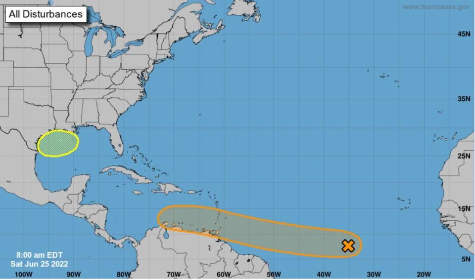
Meteorologists are monitoring a tropical wave located over the central tropical Atlantic. It could develop and form a tropical depression during the early to middle part of next week, according to the National Hurricane Center.
This system is forecast to move westward at 15 to 20 mph over the tropical Atlantic and approach the Windward Islands by Tuesday and move into the southeastern Caribbean Sea by Wednesday.
NHC experts give it a 30 percent change of forming through the next 48 hours, then chances for formation increase to 60 percent over the next five days.
Meteorologists are also watching a weak disturbance that will cross the Florida peninsula and track westward across the Gulf of Mexico early in the coming week, according to Accuweather.com. This system has zero to 20 percent change of developing.
There have been no named storms in the Atlantic since Alex dissipated on June 6. The next storm will be Bonnie.
8 am EDT Jun 25: A tropical depression could form over the tropical Atlantic during the early to middle part of next week while it moves westward, approaching the Windward Islands on Tue and the SE Caribbean by Wed.
Next outlook at 2 pm. Latest updates: https://t.co/tW4KeFW0gB pic.twitter.com/AEQzAU5Y8G— National Hurricane Center (@NHC_Atlantic) June 25, 2022
► Your guide to preparing for the 2022 hurricane season in Florida
What's out there and where are they?
labeled Invest 94L for now, the tropical wave located over the central tropical Atlantic southwest of Cape Verde. It's producing a large area of disorganized showers and thunderstorms.
Other tropical waves
Meteorologists are watching a weak disturbance that will cross the Florida peninsula and track westward across the Gulf of Mexico early in the coming week. This disturbance will have a small window to become better organized from Monday to Wednesday before it moves inland across southeast Texas. This has a low chance at briefly develop into a tropical depression or storm, though regardless can threaten southeast Texas with heavy downpours around the middle of the week.
How likely are they to strengthen?
Environmental conditions appear conducive for development of Invest 94L over the next few days, and a tropical depression could form during the early to middle part of next week as it moves west at around 15 mph over the tropical Atlantic and approaches the Windward Islands.
Formation chance through 48 hours: low, 30%.
Formation chance through 5 days: medium, 60%.
Who is likely to be impacted?
It's too early at this time to determine if there will be any impact to the U.S. from Invest 94L as it moves toward the Caribbean.
Forecasters urge all residents to continue monitoring the tropics and to always be prepared during what's expected to be an active hurricane season.
Weather watches and warnings issued for your area
If you can't see any local weather warnings here, you'll need to open this story in a web browser.
What's next?
We will continue to update our tropical weather coverage daily. Download your local site's app to ensure you're always connected to the news. And look at our special subscription offers here.
This article originally appeared on Naples Daily News: Tropical wave Invest 94L could become tropical depression next week
