Aton Announces the Completion of and the First Results from Its RC Exploration Drilling Programme at Abu Marawat
VANCOUVER, BC / ACCESSWIRE / October 11, 2023 / Aton Resources Inc. (TSXV:AAN) ("Aton" or the "Company") is pleased to announce the completion of the reverse circulation percussion ("RC") programme drilling at its 100% owned Abu Marawat Concession ("Abu Marawat" or the "Concession"), in the Eastern Desert of Egypt, as well as the first results from the West Garida and Abu Gaharish prospects (Figure 1).
Highlights:
85 holes were drilled, for a total of 11,700m, during the regional exploration RC programme at the West Garida, Abu Gaharish, Semna and Zeno prospects;
A further 628m was drilled from 3 groundwater exploration holes approximately 20km west of the Hamama project area;
Significant flows were recorded from the groundwater exploration holes within Nubian Sandstone cover rocks, proving the concept that this unit could provide process water supplies for the planned Hamama West and Rodruin mining projects;
Significant mineralised intersections from the Abu Gaharish prospect included 9m @ 2.10 g/t Au, 3m @ 4.61 g/t Au and 3m @ 3.27 g/t Au. The gold mineralisation was primarily concentrated in a broadly mineralised envelope at the Gaharish Main Zone;
Narrow mineralised intersections at West Garida included 2m @ 3.66 g/t Au and 24.3 g/t Ag from Vein #1 and 1m @ 4.00 g/t Au from Vein #3.
"We are pleased to announce the successful completion of the regional RC exploration drilling programme at Abu Marawat, and to provide the first tranche of results" said Tonno Vahk, Interim CEO. "We are particularly happy with the results of the groundwater drilling in the Nubian Sandstone west of Hamama, designed to test the potential of these rocks to provide process water supplies to the planned starter heap leach mining project at Hamama West. The results were very encouraging with the drilling intersecting significant groundwater hosted in the Nubian cover. It is particularly encouraging that the drilling did not penetrate deep enough to intersect the main target, the basal Tarif Sandstone Unit of the Nubian, which suggests that this unit may host significant groundwater resources closer to Hamama than was previously anticipated. EMRA continue to review our submission to them detailing Commercial Discoveries at the Hamama West and Rodruin deposits, in accordance with the terms of the Abu Marawat Concession Agreement, and we are hopeful that this process is moving towards a successful conclusion and the issuance of the mining licence at Abu Marawat. The issuance of the first gold mining licence in Egypt to a publicly listed foreign investor since Sukari in 2005 would represent a very significant step forwards for Aton, as well as for Egypt, the Ministry of Petroleum and EMRA."
2023 Abu Marawat RC drilling programme
The exploration RC drilling, undertaken by Geodrill's Egyptian branch, Geodrill for Leasing and Specialized Services Freezone LLC, commenced at the West Garida prospect, 3km east of Hamama West. Prior to the rig being mobilised to Abu Gaharish, 3 groundwater exploration holes were also drilled to test the Nubian Sandstone aquifer approximately 20km west of the Hamama project. Drilling at Abu Gaharish, and subsequently at the Semna and Zeno prospects was supported by fly camps. The drill metres for the programme are summarised in Table 1.
Project | Number of holes | Total metres |
Groundwater exploration (Nubian Sandstone) | 3 | 628 |
West Garida | 21 | 1,522 |
Abu Gaharish | 22 | 3,300 |
Semna | 21 | 3,662 |
Zeno | 21 | 3,216 |
Total | 88 | 12,328 |
Table 1: Breakdown of the RC drilling completed
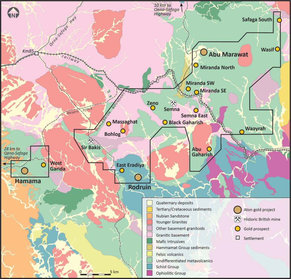
Figure 1: Geology and prospect plan of the Abu Marawat Concession
Groundwater exploration drilling
2 holes HAW-01 and HAW-02 were drilled south of the Hamama access road approximately 20km west of the Hamama West mineral deposit to test the potential of the Nubian Sandstone Formation to produce sufficient volumes of process water for the proposed Hamama West. Hole HAW-03 was drilled approximately 4km further east of HAW-01, back towards Hamama. Details and locations of the holes are provided in Table 2.
Hole ID | Collar co-ordinates 1,2 | EOH depth (m) | Dip | Grid azimuth | Comments | ||
X | Y | Z | |||||
HAW-01 | 517072 | 2910962 | 291 | 100 | -90 | - | Hole dry |
HAW-02 | 516679 | 2909410 | 285 | 294 | -90 | - | c. 700 l/min flow from 270m depth |
HAW-03 | 520792 | 2911753 | 315 | 234 | -90 | - | c. 480 l/min flow from 222m depth |
Notes:
| |||||||
Table 2: Collar details of groundwater exploration drill holes
The RC holes were drilled at 5¾" diameter, with holes HAW-02 and HAW-03 reducing to 5½" diameter. Holes HAW-01 and HAW-02 were cased through the surface alluvial sheet wash deposits to 12m depth, and HAW-03 was cased to 30m depth.
Hole HAW-01 failed to intersect any water by its target depth of 100m, and was terminated. Holes HAW-02 and HAW-03 both intersected significant groundwater from about 120m depth, with the drillers unable to keep the holes and samples dry (Figure 2). Hole HAW-02 was terminated at 294m, and HAW-03 was terminated at 234m, due to the hole collapsing in water-bearing sandstones.
All holes were drilled through a variegated sequence of predominantly brown, red, grey and black shales and mudstones, with intercalated sandstone units interpreted as belonging to the Quseir Unit of the Cretaceous Nubian Sandstone Formation. The target basal Tarif Sandstone Unit of the Nubian Sandstone Formation was not intersected in any of the 3 holes.

Figure 2: Drilling on groundwater exploration hole HAW-02
Both holes HAW-02 and HAW-03 started making significant amounts of water from about 120m onwards, with the volume increasing with depth. Water was primarily hosted within sandstone horizons intercalated with the predominantly shale and mudstone sequence. Airlift testing was carried out on both holes, using the booster compressor, but no formal pump testing was undertaken. Water flows were measured using a V-notch weir system. Significant water flows were recorded from both holes HAW-02 and HAW-03, to a maximum of c. 700 l/min from 270m depth, and 480 l/min from 220m depth, respectively.
The programme has successfully proved the concept that the Nubian Sandstone cover which outcrops to the west of the Hamama area could potentially host sufficient groundwater resources to provide process water for the proposed Hamama West open mine and heap leach project. It is noted that the drilling failed to intersect the deeper basal Tarif Sandstone Unit of the Nubian Sandstone Formation that was the primary target of the programme. The Nubian Sandstone cover dips west towards the Nile River basin, which suggests that the Tarif Formation aquifer could be potentially intersected and exploited for groundwater at shallower depths and further east towards the Hamama project, thus reducing the required pumping distance.
Exploration RC drilling
West Garida
21 drill holes, WGP-006 to WGP-025, were completed at the West Garida prospect (Figure 1), for a total of 1,522m metres (Table 3 and Figure 3). The mineralisation at West Garida is associated with several narrow shallow-dipping coarse gold-bearing quartz veins, with the drilling designed to follow up on a previous RC drill intersection of 41.7 g/t Au, 263 g/t Ag and 2.08% Pb over a 1m interval in hole WGP-003 (see news release dated September 1, 2022).
Hole ID | Collar co-ordinates 1,2 | EOH depth (m) | Dip | Grid azimuth | Comments | ||
X | Y | Z | |||||
WGP-006 | 537327.4 | 2914773.9 | 630.6 | 100 | -71.3 | 0.8 | Vein #1 |
WGP-007 | 537327.4 | 2914776.0 | 630.6 | 100 | -51.3 | 3.1 | Vein #1 |
WGP-008 | 537327.1 | 2914762.7 | 630.6 | 57 | -65.0 | 179.6 | Vein #1 (hole abandoned) |
WGP-008a | 537327.4 | 2914766.2 | 630.6 | 120 | -64.8 | 181.1 | Vein #1 (re-drill of WGP-008) |
WGP-009 | 537327.5 | 2914767.1 | 630.7 | 110 | -78.7 | 180.6 | Vein #1 |
WGP-010 | 537240.4 | 2914803.6 | 614.7 | 60 | -48.1 | 1.4 | Vein #1 |
WGP-011 | 537240.2 | 2914800.3 | 614.9 | 60 | -89.5 | 351.9 | Vein #1 |
WGP-012 | 537238.9 | 2914737.2 | 629.7 | 100 | -55.0 | 358.1 | Vein #1 |
WGP-013 | 537239.0 | 2914735.6 | 629.8 | 100 | -74.3 | 1.1 | Vein #1 |
WGP-014 | 537239.0 | 2914734.6 | 629.9 | 100 | -90.0 | 0.0 | Vein #1 |
WGP-015 | 537239.1 | 2914728.3 | 630.1 | 110 | -80.6 | 189.1 | Vein #1 |
WGP-016 | 536845.5 | 2914990.0 | 637.6 | 40 | -89.8 | 221.4 | Vein #2 |
WGP-017 | 536847.7 | 2914991.3 | 637.7 | 40 | -50.0 | 59.5 | Vein #2 |
WGP-018 | 536797.7 | 2914961.8 | 634.3 | 40 | -50.6 | 58.8 | Vein #2 |
WGP-019 | 536795.2 | 2914960.6 | 634.2 | 50 | -89.6 | 335.8 | Vein #2 |
WGP-020 | 536790.9 | 2914958.3 | 633.9 | 75 | -55.4 | 237.7 | Vein #2 |
WGP-021 | 536780.6 | 2915143.5 | 627.5 | 50 | -50.5 | 129.2 | Vein #3 |
WGP-022 | 536778.6 | 2915145.1 | 627.4 | 60 | -89.4 | 147.9 | Vein #3 |
WGP-023 | 536775.8 | 2915147.1 | 627.3 | 70 | -59.2 | 311.5 | Vein #3 |
WGP-024 | 536836.9 | 2914991.5 | 637.2 | 40 | -50.3 | 315.4 | Vein #2 |
WGP-025 | 536845.1 | 2914986.0 | 637.6 | 40 | -50.1 | 179.5 | Vein #2 |
Notes:
| |||||||
Table 3: Collar details of RC exploration drill holes at West Garida

Figure 3: West Garida drill hole collar plan
Hole ID | Intersection (m) | Assays (ppm) | Comments | ||||||
From | To | Interval | Au | Ag | Cu | Pb | Zn | ||
WGP-010 | 35 | 36 | 1 | 2.03 | 1.6 | 35 | 23 | 164 | Vein #1 |
WGP-011 | 24 | 25 | 1 | 2.35 | 10.1 | 215 | 900 | 1,390 | Vein #1 |
WGP-012 | 50 | 52 | 2 | 3.66 | 24.3 | 36 | 867 | 75 | Vein #1 |
WGP-018 | 21 | 22 | 1 | 3.25 | 24.0 | 221 | 2,870 | 3,100 | Vein #2 |
WGP-023 | 68 | 69 | 1 | 4.00 | 4.9 | 217 | 7 | 1,800 | Vein #3 |
Table 4: Significant intersections from West Garida
The drill holes generally intersected the targeted mineralised structures (Veins #1, #2 and #3, see Figure 3). All mineralised intercepts from the West Garida drilling are provided in Appendix A, with significant intersections shown in Table 4 above. The drilling largely confirmed the presence and continuity of the shallow dipping mineralised structures, but did not replicate the high grades from surface sampling of the coarse-gold bearing structures, nor the results of hole WGP-003 (see news release dated September 1, 2022).
Abu Gaharish
Hole ID | Collar co-ordinates 1,2 | EOH depth (m) | Dip | Grid azimuth | Comments | ||
X | Y | Z | |||||
GHP-001 | 564503.2 | 2917326.1 | 481.7 | 200 | -53.1 | 79.6 | Main Zone |
GHP-002 | 564431.0 | 2917336.0 | 477.3 | 200 | -53.4 | 79.0 | Main Zone |
GHP-003 | 564372.9 | 2917345.9 | 478.1 | 150 | -52.0 | 90.9 | Main Zone |
GHP-004 | 564307.4 | 2917342.2 | 478.8 | 150 | -55.6 | 88.5 | Main Zone |
GHP-005 | 564239.3 | 2917351.0 | 478.1 | 120 | -56.5 | 93.0 | Main Zone |
GHP-006 | 564488.8 | 2917177.5 | 480.7 | 200 | -53.8 | 91.0 | Main Zone |
GHP-007 | 564420.8 | 2917179.8 | 479.6 | 200 | -55.0 | 90.3 | Main Zone |
GHP-008 | 564347.1 | 2917185.3 | 483.0 | 150 | -55.3 | 90.4 | Main Zone |
GHP-009 | 564701.8 | 2916804.0 | 516.5 | 150 | -54.1 | 90.3 | SE shear |
GHP-010 | 564630.2 | 2916659.1 | 533.2 | 120 | -54.8 | 88.2 | SE shear |
GHP-011 | 564406.4 | 2916699.0 | 495.9 | 100 | -53.7 | 89.4 | SW shear |
GHP-012 | 563841.5 | 2916890.5 | 490.6 | 140 | -49.7 | 70.9 | Stockwork zone |
GHP-013 | 563919.9 | 2916955.1 | 508.9 | 140 | -47.7 | 74.9 | Stockwork zone |
GHP-014 | 563996.0 | 2916983.4 | 501.8 | 140 | -50.8 | 71.5 | Stockwork zone |
GHP-015 | 564566.5 | 2917491.7 | 470.6 | 150 | -53.7 | 88.7 | Main Zone |
GHP-016 | 564523.1 | 2917500.6 | 475.4 | 200 | -53.4 | 84.3 | Main Zone |
GHP-017 | 564447.2 | 2917507.1 | 474.2 | 160 | -54.0 | 89.7 | Main Zone |
GHP-018 | 564562.3 | 2918038.7 | 464.3 | 120 | -54.5 | 89.9 | Ionic leach anomaly |
GHP-019 | 564491.8 | 2918038.3 | 465.3 | 120 | -55.0 | 90.9 | Ionic leach anomaly |
GHP-020 | 564460.4 | 2918197.8 | 462.5 | 120 | -53.1 | 90.7 | Ionic leach anomaly |
GHP-021 | 564392.0 | 2918198.2 | 461.7 | 120 | -54.7 | 91.4 | Ionic leach anomaly |
GHP-022 | 564996.4 | 2918271.1 | 488.2 | 150 | -54.9 | 105.3 | NEX Vein zone |
Notes:
| |||||||
Table 5: Collar details of RC exploration drill holes at Abu Gaharish
22 drill holes, GHP-001 to GHP-022, were completed at the Abu Gaharish prospect (Figure 1), for a total of 3,300m metres (Table 5 and Figure 4) in this first pass programme. Holes were drilled over a broad area covering c. 1.7km of strike length of mineralisation that roughly parallels the contact of the Gaharish alkali granite pluton with the surrounding metasedimentary and metavolcanic package of country rocks. 11 holes were drilled at the Gaharish Main Zone, which was the main focus of ancient and recent artisanal mine workings (GHP-001 to GHP-008, and GHP-015 to GHP-017), 3 holes were drilled to test shear structures located within country rock package (GHP-009 to GHP-011), 3 holes were drilled to test a possible stockwork and sheeted vein zone southwest of the Main Zone, and within the Gaharish pluton itself (GHP-012 to GHP-014), 4 holes were drilled to test an ionic leach wadi sediment geochemical anomaly (GHP-018 to GHP-021), and the final hole was drilled to test the North East Extension ("NEX") Vein structure, along strike and north-northeast of the Main Zone (GHP-022). The collar locations of all the drill holes are shown in Figure 4.

Figure 4: Abu Gaharish drill hole collar plan
All mineralised intercepts from the Abu Gaharish drilling are provided in Appendix B, with significant intersections shown in Table 6. The drilling identified a broad mineralised envelope over a c. 350m strike length associated with the Main Zone, containing higher grade structures, which returned intercepts including 2m @ 8.16 g/t Au and 3m @ 4.61 g/t Au. Screen fire assay of a single 1m sample indicated the presence of coarse gold in these zones. Narrow lower grade intercepts were returned from the southern shear structures in the country rocks, and a broad low grade interval in hole GHP-012 indicated the potential for sheeted vein style reduced intrusion-related gold ("RIRG") style mineralisation to the southwest of the Main Zone.
Hole ID | Intersection (m) | Assays (ppm) | Comments | ||||||
From | To | Interval | Au | Ag | Cu | Pb | Zn | ||
GHP-001 | 1 | 5 | 4 | 2.70 | 2.2 | 69 | 193 | 181 | Main Zone |
and | 61 | 70 | 9 | 2.10 | 2.3 | 57 | 385 | 457 | |
incl. | 65 | 67 | 2 | 8.16 | 8.3 | 205 | 1,568 | 1,706 | |
GHP-002 | 55 | 56 | 1 | 6.69 | 10.2 | 70 | 750 | 363 | Main Zone |
GHP-006 | 80 | 83 | 3 | 3.27 | 5.9 | 47 | 199 | 394 | Main Zone |
and | 124 | 126 | 2 | 3.52 | 8.1 | 58 | 126 | 359 | |
GHP-007 | 8 | 10 | 2 | 3.78 | 1.3 | 14 | 190 | 188 | Main Zone |
GHP-015 | 11 | 13 | 2 | 2.98 | 4.1 | 40 | 200 | 329 | Main Zone |
and | 49 | 50 | 1 | 4.77 | - | - | - | - | Gold by screen fire assay, coarse gold present |
GHP-016 | 37 | 42 | 5 | 1.23 | 0.5 | 14 | 26 | 102 | Main Zone |
and | 49 | 52 | 3 | 4.61 | 14.8 | 186 | 967 | 849 | |
Table 6: Significant intersections from Abu Gaharish
Sampling and analytical procedures
The RC holes were drilled at 5¾" or 5½" diameter, and the bulk percussion chip samples were collected directly into pre-written large plastic bags from the cyclone every metre, numbered with the hole number and hole depths, and laid out sequentially at the drill site. Between each metre of drilling the cyclone and top box were cleaned out with compressed air. The bags were logged on the drill sites by Aton geologists. The bulk 1m samples were weighed, and subsequently riffle split through a 3-tier splitter onsite by Aton field staff to produce an approximately 1/8 split, which was collected in cloth bags, numbered and tagged with the hole number and depth. The splitter was cleaned with compressed air between each sample. The reject material from this initial bulk split was re-bagged, labelled and tagged, and retained on the drill sites. A representative sample of each metre was washed and stored in marked plastic chip trays, each containing 20m of samples, photographed, and retained onsite as a permanent record of the drill hole.
The 1m split samples, weighing approximately 5kg each were then transported to the Rodruin sample processing facility, where they were 1/2 riffle split into 2 separate sub-samples, weighing approximately 2.5kg. One of these sub-samples was marked and labelled, and retained at the laboratory for storage. The second 1m sub-samples were then combined into 4m composite samples, weighing approximately 10kg. These were thoroughly mixed and again riffle split to produce nominal c. 250-500g 4m composite samples which were dispatched to ALS Minerals for analysis. Again the splitter was cleaned with compressed air between each sample. The 4m composite samples were allocated new sample numbers. The bulk reject material from the riffle split 4m composite samples was disposed of. QAQC samples were inserted into the 4m composite sample stream at a rate of approximately 1 certified reference material (or "standard" sample) every 60 samples, 1 blank sample every 30 samples, and 1 field duplicate split sample every 30 samples.
The 4m composite samples were shipped to ALS Minerals sample preparation laboratory at Marsa Alam, Egypt, where they were pulverised to a size fraction of better than 85% passing 75 microns. From this pulverised material a further sub-sample was split off with a nominal c. 50g size, which was shipped on to ALS Minerals at Rosia Montana, Romania for analysis. The 4m composite samples were analysed for gold by fire assay with an atomic absorption spectroscopy ("AAS") finish (analytical code Au-AA23. Any high grade samples (Au >10 g/t) were re-analysed using analytical code Au-GRA21 (also fire assay, with a gravimetric finish).
Upon receipt of the final 4m composite assay results from ALS, a number of the retained 1m sub-samples were selected by a senior Aton geologist for re-assaying, corresponding to 4m composite assays deemed to be of significance. The selected 1m sub-samples were again riffle split to produce nominal c. 250-500g 1m split samples which were again allocated new sample numbers. These were dispatched to ALS Minerals for the same sample preparation at Marsa Alam, and for subsequent analysis at Rosia Montana. The bulk reject material from the 1m sub-sample splits was re-bagged and retained onsite for storage at Rodruin. QAQC samples were inserted into the 1m split sample stream at a rate of approximately 1 standard every 30 samples, 1 blank sample every 15 samples, and 1 field duplicate split sample every 15 samples.
The 1m split samples were again analysed for gold by fire assay (analytical code Au-AA23), and for silver, copper, lead and zinc using an aqua regia digest followed by an AAS finish (analytical code AA45). Any high grade gold samples (Au >10 g/t) were again re-analysed using analytical code Au-GRA21 (also fire assay, with a gravimetric finish). Any high grade Ag and base metal samples (Ag >100 g/t, and Cu, Pb and Zn >10,000ppm or >1%) were re-analysed using the ore grade technique AA46 (also an aqua regia digest followed by an AAS finish).
All intersections herein reported relate to 1m split samples.
About Aton Resources Inc. Aton Resources Inc. (AAN: TSX-V) is focused on its 100% owned Abu Marawat Concession ("Abu Marawat"), located in Egypt's Arabian-Nubian Shield, approximately 200 km north of Centamin's world-class Sukari gold mine. Aton has identified numerous gold and base metal exploration targets at Abu Marawat, including the Hamama deposit in the west, the Abu Marawat deposit in the northeast, and the advanced Rodruin exploration prospect in the south of the Concession. Two historic British gold mines are also located on the Concession at Sir Bakis and Semna. Aton has identified several distinct geological trends within Abu Marawat, which display potential for the development of a variety of styles of precious and base metal mineralisation. Abu Marawat is 447.7 km 2 in size and is located in an area of excellent infrastructure; a four-lane highway, a 220kV power line, and a water pipeline are in close proximity, as are the international airports at Hurghada and Luxor. | Qualified person The technical information contained in this News Release was prepared by Javier Orduña BSc (hons), MSc, MCSM, DIC, MAIG, SEG(M), Exploration Manager of Aton Resources Inc. Mr. Orduña is a qualified person (QP) under National Instrument 43-101 Standards of Disclosure for Mineral Projects. |
Some of the statements contained in this release are forward-looking statements. Since forward-looking statements address future events and conditions; by their very nature they involve inherent risks and uncertainties. Actual results in each case could differ materially from those currently anticipated in such statements. | |
Appendix A - Significant intersections from the West Garida prospect
Hole ID | Intersection (m) | Assays (ppm) | Comments | ||||||
From | To | Interval | Au | Ag | Cu | Pb | Zn | ||
WGP-006 | 67 | 68 | 1 | 0.34 | 1.3 | 68 | 11 | 230 | |
WGP-007 | 85 | 86 | 1 | 0.42 | 2.0 | 91 | 16 | 248 | |
WGP-008a | 86 | 87 | 1 | 0.42 | 3.6 | 71 | 25 | 875 | |
WGP-009 | 72 | 75 | 3 | 0.68 | 2.4 | 151 | 24 | 2,821 | |
WGP-010 | 28 | 29 | 1 | 1.37 | 1.2 | 84 | 155 | 875 | |
and | 35 | 36 | 1 | 2.03 | 1.6 | 35 | 23 | 164 | |
WGP-011 | 24 | 25 | 1 | 2.35 | 10.1 | 215 | 900 | 1,390 | |
WGP-012 | 50 | 52 | 2 | 3.66 | 24.3 | 36 | 867 | 75 | |
WGP-013 | - | - | - | - | - | - | - | - | NSA > 0.06 g/t Au |
WGP-014 | - | - | - | - | - | - | - | - | NSA > 0.04 g/t Au |
WGP-015 | - | - | - | - | - | - | - | - | NSA > 0.17 g/t Au |
WGP-016 | - | - | - | - | - | - | - | - | NSA > 0.20 g/t Au |
WGP-017 | 23 | 25 | 2 | 1.79 | 33.2 | 509 | 497 | 3,595 | |
WGP-018 | 21 | 22 | 1 | 3.25 | 24.0 | 221 | 2,870 | 3,100 | |
WGP-019 | 25 | 26 | 1 | 1.90 | 18.6 | 106 | 1,445 | 1,360 | |
WGP-020 | - | - | - | - | - | - | - | - | NSA > 0.04 g/t Au |
WGP-021 | 32 | 34 | 2 | 0.32 | 1.1 | 156 | 35 | 2,240 | |
WGP-022 | 21 | 22 | 1 | 0.40 | 0.3 | 45 | 8 | 299 | |
and | 33 | 34 | 1 | 0.36 | 0.8 | 54 | 13 | 177 | |
and | 51 | 52 | 1 | 0.47 | 0.5 | 74 | 10 | 76 | |
WGP-023 | 49 | 50 | 1 | 0.62 | 1.3 | 71 | 11 | 720 | |
and | 68 | 69 | 1 | 4.00 | 4.9 | 217 | 7 | 1,800 | |
WGP-024 | 20 | 22 | 2 | 0.70 | 15.7 | 527 | 847 | 1,870 | |
WGP-025 | 26 | 27 | 1 | 0.55 | 24.0 | 242 | 819 | 1,705 | |
Notes:
| |||||||||
Appendix B - Significant intersections from the Abu Gaharish prospect
Hole ID | Intersection (m) | Assays (ppm) | Comments | ||||||
From | To | Interval | Au | Ag | Cu | Pb | Zn | ||
GHP-001 | 1 | 5 | 4 | 2.70 | 2.2 | 69 | 193 | 181 | Main Zone |
and | 18 | 19 | 1 | 2.82 | 5.1 | 31 | 733 | 344 | |
and | 51 | 53 | 2 | 1.38 | 1.4 | 17 | 93 | 215 | |
and | 61 | 70 | 9 | 2.10 | 2.3 | 57 | 385 | 457 | |
incl. | 65 | 67 | 2 | 8.16 | 8.3 | 205 | 1,568 | 1,706 | |
and | 76 | 77 | 1 | 3.19 | 2.2 | 12 | 315 | 1010 | |
and | 96 | 97 | 1 | 0.88 | 5.1 | 17 | 223 | 349 | |
GHP-002 | 55 | 56 | 1 | 6.69 | 10.2 | 70 | 750 | 363 | Main Zone |
and | 98 | 100 | 2 | 0.79 | 1.2 | 22 | 38 | 48 | |
and | 115 | 116 | 1 | 0.51 | 1.2 | 11 | 35 | 58 | |
GHP-003 | 96 | 97 | 1 | 0.50 | 0.9 | 48 | 10 | 65 | Main Zone |
GHP-004 | 87 | 88 | 1 | 0.63 | 0.7 | 28 | 8 | 53 | Main Zone |
GHP-005 | 12 | 13 | 1 | 1.03 | 0.8 | 17 | 85 | 32 | Main Zone |
GHP-006 | 68 | 69 | 1 | 0.58 | 0.8 | 14 | 27 | 83 | Main Zone |
and | 80 | 83 | 3 | 3.27 | 5.9 | 47 | 199 | 394 | |
and | 124 | 126 | 2 | 3.52 | 8.1 | 58 | 126 | 359 | |
and | 131 | 132 | 1 | 0.96 | 0.9 | 12 | 89 | 346 | |
GHP-007 | 8 | 10 | 2 | 3.78 | 1.3 | 14 | 190 | 188 | Main Zone |
and | 54 | 55 | 1 | 0.89 | 2.3 | 81 | 148 | 125 | |
and | 67 | 68 | 1 | 0.73 | 1.2 | 19 | 9 | 82 | |
and | 112 | 113 | 1 | 0.50 | 0.7 | 15 | 21 | 59 | |
GHP-008 | 59 | 60 | 1 | 1.13 | 0.5 | 14 | 22 | 58 | Main Zone |
and | 102 | 104 | 2 | 0.79 | 0.8 | 6 | 11 | 58 | |
and | 141 | 142 | 1 | 0.50 | 2.0 | 13 | 60 | 138 | |
GHP-009 | - | - | - | - | - | - | - | - | NSA > 0.265 g/t Au (SE Shear) |
GHP-010 | 43 | 44 | 1 | 0.64 | 1.2 | 58 | 8 | 82 | SE Shear |
GHP-011 | 55 | 57 | 2 | 1.36 | 0.9 | 35 | 27 | 111 | SW Shear |
GHP-012 3 | 0 | 29 | 29 | 0.28 | 0.3 | 9 | 15 | 56 | Stockwork zone, possible RIRG style mineralisation? |
GHP-013 | 52 | 53 | 1 | 2.50 | 3.4 | 8 | 29 | 79 | Stockwork zone |
and | 75 | 78 | 3 | 0.51 | 0.6 | 8 | 25 | 76 | |
GHP-014 | - | - | - | - | - | - | - | - | NSA > 0.213 g/t Au (stockwork zone) |
GHP-015 | 11 | 13 | 2 | 2.98 | 4.1 | 40 | 200 | 329 | Main Zone |
and | 17 | 19 | 2 | 0.89 | 1.9 | 17 | 63 | 136 | |
and | 34 | 35 | 1 | 1.02 | 1.1 | 21 | 77 | 208 | |
and | 49 | 50 | 1 | 4.77 | - | - | - | - | Gold by screen fire assay, coarse gold present |
and | 55 | 57 | 2 | 1.60 | 1.3 | 21 | 60 | 221 | |
GHP-016 | 12 | 13 | 1 | 0.57 | 0.6 | 12 | 106 | 131 | Main Zone |
and | 32 | 33 | 1 | 0.73 | 0.8 | 13 | 203 | 248 | |
and | 37 | 42 | 5 | 1.23 | 0.5 | 14 | 26 | 102 | |
and | 49 | 52 | 3 | 4.61 | 14.8 | 186 | 967 | 849 | |
and | 61 | 62 | 1 | 1.46 | 1.4 | 6 | 80 | 198 | |
Hole ID | Intersection (m) | Assays (ppm) | Comments | ||||||
From | To | From | To | From | To | From | To | ||
GHP-016 | 86 | 87 | 1 | 0.70 | 0.6 | 5 | 119 | 66 | |
and | 90 | 91 | 1 | 0.72 | 1.2 | 11 | 59 | 87 | |
and | 102 | 103 | 1 | 0.82 | 0.6 | 58 | 11 | 59 | |
GHP-017 | 105 | 106 | 1 | 1.71 | 2.2 | 17 | 68 | 86 | Main Zone |
and | 119 | 120 | 1 | 1.35 | 0.6 | 3 | 90 | 324 | |
and | 123 | 125 | 2 | 0.65 | 0.9 | 15 | 30 | 66 | |
GHP-018 | - | - | - | - | - | - | - | - | NSA > 0.099 g/t Au (IL anomaly) |
GHP-019 | - | - | - | - | - | - | - | - | NSA > 0.117 g/t Au (IL anomaly) |
GHP-020 | - | - | - | - | - | - | - | - | NSA > 0.175 g/t Au (IL anomaly) |
GHP-021 | - | - | - | - | - | - | - | - | NSA > 0.144 g/t Au (IL anomaly) |
GHP-022 | - | - | - | - | - | - | - | - | NSA > 0.109 g/t Au (NEX Vein) |
Notes:
| |||||||||
SOURCE: Aton Resources, Inc.
View source version on accesswire.com:
https://www.accesswire.com/791793/aton-announces-the-completion-of-and-the-first-results-from-its-rc-exploration-drilling-programme-at-abu-marawat
