Kelluu Unmanned Airships Equipped with AgEagle’s RedEdge-P Multispectral Sensors Take Environmental and Critical Infrastructure Inspection and Monitoring to Entirely New Level in Finland

AgEagle Aerial Systems, Inc.
WICHITA, Kan., Aug. 23, 2023 (GLOBE NEWSWIRE) -- AgEagle Aerial Systems Inc. (NYSE American: UAVS) (“AgEagle” or the “Company”), an industry-leading provider of full stack flight hardware, sensors and software for commercial and government use, today announced that Kelluu Ltd., a privately-owned Finnish company engaged in the design, manufacture and operation of autonomous airships for aerial environmental and critical infrastructure monitoring and surveillance, has chosen to equip its growing fleet of unmanned airships with AgEagle’s high performance RedEdge-P™ multispectral cameras for collection of high quality images and sensor data.
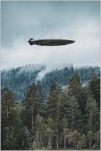
Based in Joensuu, Finland, Kelluu has pioneered low-emission, hydrogen-powered airships that can remain airborne for more than 12 hours per mission. With its airships, Kelluu offers commercial enterprises and government agencies with data-as-a-service, specializing in monitoring and providing real-time, actionable intelligence on power lines, roads and railways, as well as surveilling and monitoring potential environmental issues associated with forest lands and water bodies across Finland – and soon across Central Europe.
Production of processed raw materials from Finland’s forest lands into sawn wood and paper products is a EUR 15 billion a year market, making it one of the nation’s most vital industries. According to the Finnish Forest Centre, more forest lands were lost in 2022 due to spruce bark beetle infestations than ever before in recorded history. On behalf of its client, the National Land Survey Institute of Finland, Kelluu is leveraging use of RedEdge-P’s high resolution, panchromatic imager for early stress detection of forests caused by bark beetle infestation at the green attack stage (when trees are yet to show distinct symptoms observable by the human eye).
“Equipped with RedEdge-P, our unmanned airships can fly for hours and surveil thousands of hectares of forest land in a single mission, pinpointing precise locations of early bark beetle infestation for immediate remediation by forestry management companies. In addition to protecting surrounding forest lands from large scale disturbances, Kelluu is now empowered to help save our customers potentially millions of euros due to mitigation of catastrophic tree losses. The RedEdge-P is a superb sensor and does its job well,” stated Jiri Jormakka, Co-Founder and Chief Operating Officer of Kelluu.
The RedEdge-P is just one of AgEagle’s leading innovations in aerial multispectral sensor technology. A single camera solution which is compatible with a wide array of unmanned aerial systems (“UAS”) ranging from large fixed wing to small multirotor to autopiloted airships, RedEdge-P captures calibrated high-resolution multispectral and RGB imagery with an optimized field of view and capture rate for efficient flights. This solution seamlessly integrates a high resolution, all-color imager with synchronized multispectral imagers to enable pixel-aligned outputs at previously unattainable resolution.
Barrett Mooney, Chairman and CEO of AgEagle, said, “We created the RedEdge-P to provide professionals with a reliable and efficient way to capture radiometrically calibrated RGB and multispectral data using leading UAS. We are very proud that innovative companies, such as Kelluu, are recognizing the value that AgEagle’s technological advancements were designed to deliver.”
To view video of Kelluu’s intelligent, unmanned airships in operation, please click here.
About AgEagle Aerial Systems Inc.
Through its three centers of excellence, AgEagle is actively engaged in designing and delivering best-in-class flight hardware, sensors and software that solve important problems for its customers. Founded in 2010, AgEagle was originally formed to pioneer proprietary, professional-grade, fixed-winged drones and aerial imagery-based data collection and analytics solutions for the agriculture industry. Today, AgEagle is a leading provider of full stack drone solutions for customers worldwide in the energy, construction, agriculture, and government verticals. For additional information, please visit our website at www.ageagle.com.
Forward-Looking Statements
This press release may contain “forward-looking statements” within the meaning of Section 27A of the Securities Act of 1933 and Section 21E of the Securities Exchange Act of 1934. Such statements involve risks and uncertainties that could negatively affect our business, operating results, financial condition, and stock price. Factors that could cause actual results to differ materially from management’s current expectations include those risks and uncertainties relating to our competitive position, the industry environment, potential growth opportunities, and the effects of regulation and events outside of our control, such as natural disasters, wars, or health epidemics. We expressly disclaim any obligation or undertaking to release publicly any updates or revisions to any forward-looking statements contained herein to reflect any change in our expectations or any changes in events, conditions, or circumstances on which any such statement is based, except as required by law.
AgEagle Aerial Systems Contacts:
Investor Relations:
Email: UAVS@ageagle.com
Media:
Email: media@ageagle.com
Attachment

