Outdated FEMA flood maps cost uninsured homeowners millions
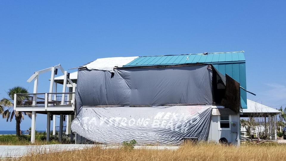
TALLAHASSEE, Fla. – Mexico Beach, Florida, was ground zero for Hurricane Michael, destroying 70% of the resort community’s homes and businesses with its Category 5 winds and 18-foot storm surge.
Because its flood maps hadn’t been updated in 10 years, 80% of those structures were uninsured because FEMA placed them in flood zone "X" – areas that have low-to-moderate risks for flooding, according to a report by My Flood Risk, an affiliate of Melbourne, Florida-based National Flood Insurance LLC.
“When it comes to uninsured flood victims in the United States, Florida’s Panhandle ranks the highest,” said Jennifer Scherff, marketing project manager for My Flood Risk. “Eighty percent of flood losses were uninsured.”
Those outdated maps pose a high risk to homeowners and business owners alike, said Amanda Bryant, director of operations for My Flood Risk. Many of those outdated flood maps are in parts of Florida hit hard by hurricanes in the last few years. Hurricane Irma caused $50 billion in damage in Florida, making it the most expensive in the state's history. Michael caused $3 billion in the Florida Panhandle.
“It is dangerously inaccurate,” Bryant said.
FEMA acknowledges the maps need updating and says they are in the process of doing so.
"FEMA recommends flood insurance coverage, even if it is not required by law or a financial lender for a mortgage, as the best protection against the unpredictable and significant financial losses a flooding event can cause," said FEMA press secretary Lizzie Litzow.
FEMA provides individual and household protection assistance to people in the "X" flood zone for their uninsured or under-insured disaster-caused expenses and serious needs if they meet the required eligibility factors, Litzow said.
Disaster insurance: Tornadoes, hurricanes and earthquakes: What does home insurance cover after a disaster?
Insurance checklist: Is your insurance policy good enough? Here's a checklist to review
Nationally, the FEMA maps are leaving some 100 million Americans and 35 to 40 million uninsured homes and businesses at risk of flooding, Bryant said. Yet only 5.5 million policies are in effect, and 40% of them are in Florida, according to FEMA's own data.
“Florida is less behind than other states but that’s because we’re the most flood-prone state of all,” Bryant said.
Chronic funding shortfall
FEMA said its mapping program has prioritized the restudy of the populated coastline for the nation since the start of FEMA’s Risk Mapping, Assessment and Planning (Risk MAP) program created around 2010, Litzow said.
"The FEMA Region IV office has been working with coastal counties across Florida, including Mexico Beach, and with the Florida Water Management Districts to update these coastal studies even prior to Hurricane Michael’s landfall last year," Litzow said.
Within the next five years, all Florida coastal counties will receive updated regulatory flood maps, Litzow said.
By statute, those maps are supposed to be updated every five years but lack of funding is preventing that from happening, Bryant said. FEMA’s debt was $20.5 billion as of December 2018.
And yet it is low on the list of priorities for Congress, she said. The latest proposal is another stop-gap reauthorization measure and not full funding, she said.
“Reauthorizations are keeping the program going along on a temporary basis,” she said. “If we want Congress to do something we may be waiting a long time and be underwater by then.”
By August, My Flood Risk hopes to have an online tool that will help property owners determine their true flood risk using seven industry-standard factors. The product will allow consumers to plug in their property address and see what flood risk factors are being considered by FEMA.
The flood maps are supposed to be updated to provide the most accurate assessment of flood risk, Scherff said, as well as recent land development and the impacts of climate change and rising sea levels.
The trouble with tides
A report released by the National Oceanic and Atmospheric Administration recently said U.S. coastal communities tied a 2015 record for high tide flooding last year, and can expect to continue experiencing them because of sea level increases. It doesn't take a big storm or hurricane to cause flooding anymore, the report said.
“U.S. coastal communities are faced with mounting challenges as sea levels rise,” Nicole LeBoeuf, acting director of NOAA’s National Ocean Service, said in a news release. “NOAA’s tide gauge observations not only ensure safe maritime navigation but are now providing critical information about changes in coastal flood risk to help communities prepare for and plan for a more resilient future.”
It no longer takes a strong storm or a hurricane to cause flooding in many coastal areas.
Five days of high tide flooding occurred in coastal communities in 2018, breaking records in the Northeast and the Eastern Gulf of Mexico, the report said.
“Once communities realize they are susceptible to high tide flooding, they need to begin to address the impacts, which can become chronic rather quickly,” said William Sweet, an oceanographer for NOAA’s Center for Operational Oceanographic Products and Services and lead author of the report.
NOAA's high tide projections can help communities plan mitigation for the years and decades ahead, Sweet said.
The national high tide flood frequency in 2019 is expected to double from 19 years ago across U.S. coastlines, with El Niño conditions playing a large role in sea-level rise. The Southeast could see a 190% increase, the report said.
That makes updating the FEMA flood maps all the more critical, Bryant said.
A roll call of Florida cities with outdated maps
FEMA flood maps for Miami-Dade and Pinellas counties are 10 years old.
Many parts of Escambia County, where only preliminary data was available, haven’t been updated since 2002 and 2006.
Parts of Panama City Beach, which sustained hundreds of millions of dollars in damage from flooding, haven’t been updated since 2009 and 2010. The City of Port St. Joe, which also was hard hit by storm surge, had its maps last updated in 2007 and 2009.
The National Flood Insurance Program celebrated its 50th anniversary last year. Since that time, there has been tremendous coastal construction sparked by a huge migration to coastal areas, and an increase in more intense hurricanes and flooding.
“It is growing year by year in leaps and bounds, causing hundreds of millions of damage to uninsured property,” Bryant said. “It’s projected to do nothing but get worse. Homeowners want protection. If your home floods and you are not insured you’re stuck.”
Follow Jeffrey Schweers on Twitter: @jeffschweers
This article originally appeared on Tallahassee Democrat: Insurance: Outdated FEMA flood maps cost uninsured homeowners millions
