Tornados, Large Hail and Thunderstorms to Hit Parts of Central US
People from central Texas to across Mississippi valley are facing a strong chance of severe storms with strong winds, large hail and even tornados, while in the Midwestern plains, heavy rains are expected to worsen what the NOAA has described as “unprecedented” flooding in the region.
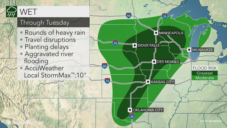
AccuWeather meteorologist Tyler Roys tells TIME that the severe weather started in parts of Texas and Oklahoma with thunderstorms, damaging wind and localized flooding on Saturday; parts of Texas also reported several tornados. Meanwhile, rain in the midwestern Plains – including South Dakota, Wisconsin and Missouri – is expected to continue until Tuesday, exacerbating the ongoing flooding.
Tornados were reported at around 6 a.m. CT in Abilene and San Angelo, Texas, Roys says. A tornado appears to have hit a baseball stadium Runnels County, Texas, although experts are still assessing the extent of the damage.
The storm is expected to move to northeast Texas and Arkansas at around 2 p.m. or 3 p.m. on Saturday afternoon. The areas are expected to experience flash flooding, large, damaging hail, and possibly tornados until about 12 a.m. on 1 a.m. on Sunday. The National Weather Service warned on Twitter that Arkansas may experience up to “ping pong” size hail.
A tornado watch has been issued for parts of Arkansas, Oklahoma and Texas until 5 PM CDT pic.twitter.com/iOynurSHuM
— NWS Tornado (@NWStornado) May 18, 2019
The midwestern plains from eastern South Dakota and Wisconsin to southern Missouri, which are facing ongoing problems with flooding, are expected to receive upwards of 10 inches of rain. Roys warns that the rain could “prolong” the flooding.
“These storms are not helping it at all,” Roys says.
Iowa, Missouri and eastern Kansas are also expected to experience strong winds and hail, especially late on Saturday afternoon and overnight. South Kansas is expected to experience largest hail, amounting to about two to three inches.
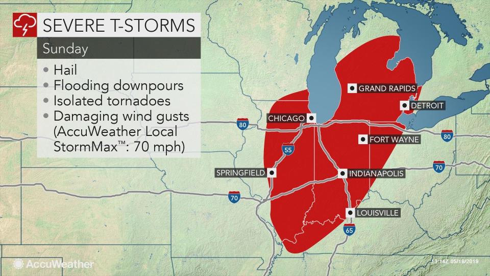
From the late morning to the afternoon on Sunday, severe storms are expected to reach the west central Ohio Valley, Chicago, Detroit and down to Louisville. These areas are expected to experience damaging, strong wind and hail.
Early next week, the central plains and mid Mississippi Valley will bear the brunt of severe weather. They’re likely to face large, damaging hail, flash flooding, wind gusts up to 80 miles per hour – and possibly tornados.