Toubani Resources: Large-Scale Gold Mineralised Shear Zones Confirmed at Kobada With Completion of Phase 1 2023 Drilling

Figure 1
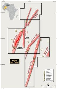
Figure 2

Figure 3
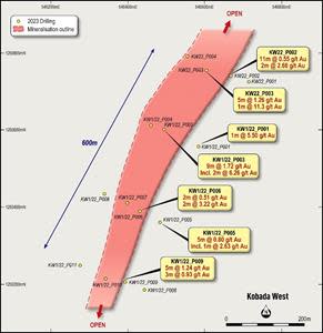
Figure 4

Figure 5
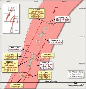
Figure 6
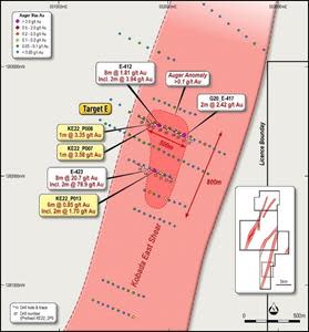
Figure 7

TORONTO, July 19, 2023 (GLOBE NEWSWIRE) -- Toubani Resources, Inc (ASX: TRE) (“Toubani Resources” or the “Company”) is pleased to provide a summary of its Phase 1 exploration program in 2023 proximal to its Kobada gold deposit (“Kobada”, “Project”) in southern Mali, following receipt of final assays. The Kobada Project hosts 3.1 Moz1 in Mineral Resources which occurs over a 4.5km strike length and is predominantly oxide and open pittable.
HIGHLIGHTS
Exploration drilling successfully extends the strike of gold mineralisation to 11km, up from 5km, with shallow, open pittable gold mineralisation intersected at all targets tested in the first phase of drilling for 2023
Significant exploration upside remains with approximately 40km of the 50km+ regional-scale shear zones yet to be drill tested – Toubani has the dominant land position in the region controlling the footprint of these structures
Drilling results support Toubani’s overall strategy of an oxide-dominant project of scale at Kobada by providing a pipeline of new oxide prospects for drill testing
Significant discovery at Kobada West with continuous, near surface oxide gold mineralisation delineated in maiden drilling, located 1km north-west from the Kobada Main Deposit
Significant strike extension to drill-defined mineralisation at Kobada North, Kobada South and Gosso
Confirmation of a new discovery at Kobada East, confirming maiden auger intercepts from 2022
Review of fresh rock potential below current oxide resource at the Kobada Main deposit supports potential for significant resource growth with mineralisation open down dip and along the entire strike extent below the current average drill depth of 110m
Drill programs planned for 2H 2023 to include both resource and regional drilling campaigns to convert Inferred Resources to Indicated and to advance regional discoveries towards maiden resources
Toubani’s dual-track strategy to unlock Kobada to continue with drill programs in 2H 2023 to form an integral part of the Company’s DFS Update due later this year
Toubani Chief Executive Officer, Phil Russo, commented: “Our Phase 1 drilling campaign provides us the confidence that with systematic exploration, a portfolio of projects providing supplementary resources to the Kobada Main Deposit can be defined. With almost all of the historical drilling to date being focused at Kobada Main, we are only in the early stages of unlocking the significant regional potential of our ground with 11km of drill-tested strike extent now defined over the 50km of interpreted structures. To intersect areas of mineralisation where there was no previous drilling is a fantastic result and demonstrates the exciting potential to grow our oxide resource base over time.
We also have an enormous opportunity below Kobada, where free milling, fresh rock mineralisation is yet to be targeted beyond 100m vertical depth, with the deposit open at depth across the entire 4.5km strike extent. We believe that significant untapped value lies in optimising and growing Kobada and this is why we announced the commencement of the DFS Update workstream earlier this month. We are excited to be pursuing that potential while also commencing a supporting parallel drilling program shortly. We remain focused on continuing to derisk Kobada as it advances rapidly along the development path and positions itself as a project of significance in the region.”
Summary of Phase 1 Program Results
Table 1: Summary of 1H 2023 drill program by target area
Target | Holes | Metres | Increase in known | Key Intersections |
Gosso | 13 | 1,793 | 650 | 1m at 5.78g/t (GO22_P024), |
Kobada East | 15 | 2,073 | 400 | 6m at 0.85g/t incl. 2m at 1.70g/t |
Kobada North 1 | 11 | 1,540 | 650 | 9m at 1.32g/t incl. 4m at 2.64g/t |
Kobada North 2 | 6 | 840 | 1,450 | 1m at 8.51g/t (KN2/22_P003) |
Kobada West | 15 | 2,073 | 600 | 9m at 1.72g/t incl. 2m at 6.26g/t |
Kobada South | 26 | 3,203 | 650 | 3m at 1.81g/t & 3m at 1.20g/t |
Junction / Foroko | 19 | 2,600 | 1,000 | 1m at 24.8g/t (KN22_P014), |
Total | 105 | 14,122 | 5,400 |
|
As shown in Table 1 the first phase of drilling in 2023 has successfully extended the extent of drill-defined mineralisation at Kobada by over 5km to 11km. The exploration strategy for this phase planned to step out from the known mineralisation at Kobada and test the potential of regional structures. While the presence and potential of these structures is well known there has only been limited historical testing.
Over 50km of regional-scale shear zones fall within the Kobada Project area, with the results from this drilling demonstrating the potential of these structures to host gold mineralisation, illustrating the exploration upside present at Kobada. These shear zones host Mineral Resources on neighbouring tenure and results to date indicate that there is the opportunity to discover and delineate further Mineral Resources within the Kobada Project.
Increasing the quantity of near-surface oxide mineralisation is significant given the Company’s belief that a bulk tonnage oxide mining and processing operation represents a lower overall technical risk profile for an initial Project (refer ASX Announcement 11th July 2023). The forthcoming Definitive Feasibility Study ("DFS") Update will focus on maximising and de-risking the oxide mining and processing phase of Kobada and the exploration potential of the broader Project represents an opportunity to generate a portfolio of targets to increase and expand the oxide phase.
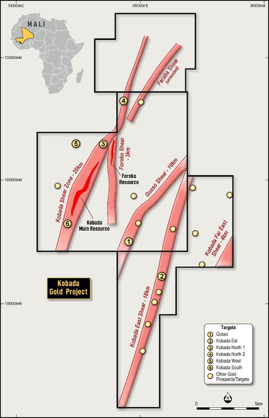
Figure 1: Plan showing 2023 drill targets within the Kobada Gold Project
Planned Resource Conversion Drilling to Support DFS Update
As detailed in the ASX Announcement dated 11 July 2023, the principle focus for the next phase of drilling at Kobada will be centred on converting material currently classed as Inferred within the DFS pit shell to Indicated. The Company has engaged an independent consultant to assist in a detailed review of the current Mineral Resource for Kobada and define priority target areas for resource conversion drilling.
Detailed drill planning will commence once the resource review has been completed shortly with the aim to commence drilling immediately following the wet season, in August or September. The program will focus on increasing confidence in near surface oxide material likely to be mined in the first 5 – 10 years of the Project.
In addition, initial geological modelling is planned for Gosso, Kobada West and Kobada East to evaluate the potential of these prospects to provide mill feed during the Project's life. Infill drilling at one or more of these prospects may also be carried out later in 2023 or early 2024.
Results of both of these drill programs will be fed directly into the DFS Update with the potential for both programs to add substantial value to the Kobada Project which already presents as a robust, near-term development opportunity.
Auger drilling is currently in progress on site testing the extensions of the Kobada Main Shear as well as the interpreted Faraba Shear some 5 kilometres along strike from the Kobada Main Deposit. Artisanal mining in this area is in progress and auger drilling is being used as a first pass technique to test below thin transported cover and laterite platforms.
Potential Future Growth in Fresh Rock Resources
The resource review will also focus on potential controls to mineralisation at Kobada, especially primary controls in the fresh mineralisation. As previously outlined, the interplay of deep-seated regional scale bounding structures with localised cross-cutting structures is the key control on higher-grade mineralisation at Kobada and surrounds, with intense shearing resulting in the concentration of high-grade quartz veins.
The average depth of drilling at Kobada to date is 110 metres which has tested the deposit down to an average vertical depth of 97 metres. With the depth to fresh rock averaging 65 metres across the deposit, and increasing to over 100 metres in places, only limited penetration into fresh rock has occurred in historical drilling.
Where drilling has extended into fresh rock, this drilling has not been targeted at discrete zones below the Kobada Main deposit. Despite this, fresh rock mineralisation has been confirmed to be present by drilling and remains open down-dip along the strike length of the deposit.
The substantial near surface gold endowment of the Kobada Main Deposit provides encouragement of the potential for a complimentary quantity of fresh rock mineralisation below or adjacent. Significant intersections in fresh rock at Kobada include3:
9m at 21.0g/t from 114m (KBRC12-066)
3m at 33.9g/t from 135m (KBRC12-066)
32.4m at 1.70g/t from 246.3m (KB07-67)
8.5m at 6.40g/t from 112m (KB07-78)
The Company anticipates that analysis of the substantial drill data as part of the resource review will yield targets within the fresh rock for future drilling.
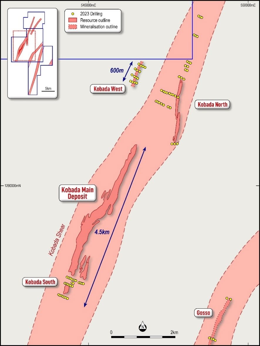
Figure 2: Plan showing targets and Toubani drilling adjacent to the Kobada Main Deposit
Target Summaries
Kobada West is located on a parallel structure just 1km north-west of the Kobada Main Deposit (Figure 1). The target area was identified by the presence of artisanal workings as well as historical surface sampling. The number of holes drilled at this target was increased during the drill program due to recent artisanal activity observed by Toubani’s geologists as well as logging of the initial drill holes.
Drilling was carried out on four sections spaced 200 metres apart as shown on Figure 3. Shallow oxide gold mineralisation was intersected on every section, over a strike length of 600m with good continuity section to section, and consistent grade and thickness. Gold mineralisation remains open along strike and depth. Results were released to the ASX on 17 May 2023 and include:
9m at 1.72g/t from 63m incl. 2m at 6.26g/t from 63m (KW1/22_P003)
1m at 11.3g/t from 129m and 5m at 1.26g/t from 116m (KW22_P003)
5m at 1.24g/t from 78m, 4m at 0.67g/t from 88m and 3m at 0.93g/t from 106m (KW22_P009)
11m at 0.55g/t from 16m, 2m at 2.66g/t from 58m and 3m at 1.12g/t from 63m (KW22_P002)
2m at 0.51g/t from 92m and 2m at 3.22g/t from 124m (KW1/22_P006)
1m at 5.50g/t from 103m (KW1/22_P001)
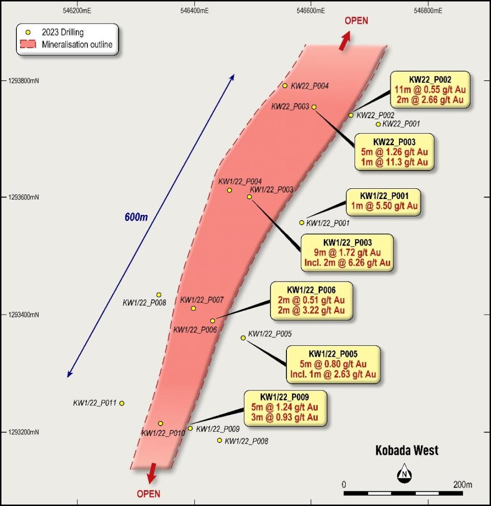
Figure 3: Plan showing Kobada West RC drilling locations and results
At Kobada North 1, two fences of drilling were completed stepping out 400 metres and 650 metres, respectively, north of the last fence of drilling within the Kobada Main resource. The drilling tested below and adjacent to artisanal workings. Results were released to the ASX on 8 March 2023 and are shown on Figure 4 with key intersections including:
9m at 1.32g/t from 112 metres including 4m at 2.64g/t (KN1/22_P009)
14m at 1.02g/t from 81 metres including 1m at 2.28g/t and 1m at 3.75g/t (KN1/22_P008)
1m at 7.86g/t from 59 metres (KN1/22_P007)
Further north at Kobada North 2, two fences of drilling were completed stepping out 1,500 metres and 2,100 metres, respectively, north of the last fence of drilling within the Kobada Main resource. The drilling tested below and adjacent to artisanal workings. Extensive artisanal workings can be found along strike and along trend from Kobada Main, yet almost no drilling has been undertaken. Drilling successfully confirmed the continuation of the system as shown on Figure 4 and detailed in the ASX Announcement of 11 April 2023 with intersections of:
1m at 8.51g/t from 48 metres (KN2/22_P003 = 1,500m north of Kobada)
1m at 0.64g/t from 137 metres (KN1/22_P010 = 2,100m north of Kobada)
Inspection of drill chips and field mapping indicates that shearing is less intense in the area of the Kobada North 2 target vs the Kobada North 1 target. Results confirm the mineralisation model of regional scale shear zones providing the first order control on mineralisation with localised cross-cutting structures providing the second order control and, importantly, controlling the higher-grade mineralisation.
With drilling successfully confirming the continuity of the mineralised system to the north, follow up drilling was carried out in the Kobada North 1 area and to test along trend back towards Kobada Main, to the west of previous drilling. This area represents the intersection of the Kobada Main shear with the Foroko Shear and has been named the Junction prospect. Results from this drilling were recently received and are detailed in Appendix 1 as well as shown on Figure 4, with intersections includes:
1m at 24.8g/t from 59 metres (KN22_P014)
1m at 9.62g/t from 82 metres and 2m at 3.38g/t from 134m (KN22_P003)
1m at 6.09g/t from 119 metres (KN22_P007)
7m at 0.70g/t from 133 metres (EOH) including 3m at 1.21g/t from 134 metres (KN22_P012)
Encouragingly the results from KN22_P014 and KN22_P007 are on trend from each other as well as along strike from the Kobada Main Deposit. A more extensive program is required to fully test the Junction target to delineate the mineralised structures present and identify areas where they are concentrated.
Auger drilling is currently underway a further 3km along strike from the Kobada North 2 Deposit, at the Faraba Prospect, where artisanal mining is currently in progress.
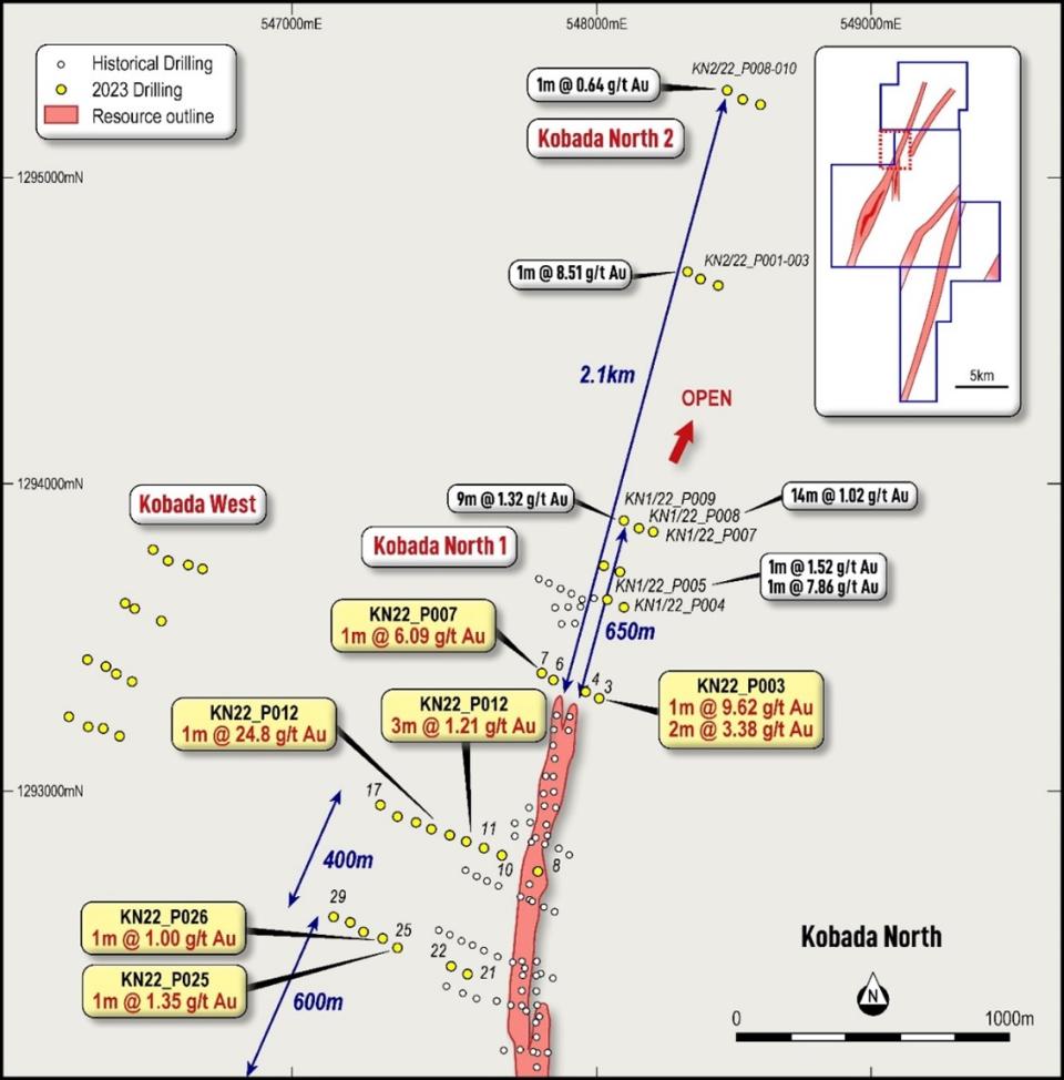
Figure 4: Plan showing Kobada North RC drilling locations and results
At Gosso, drilling aimed to test the northern and southern extents of the deposit as well as a line of drilling through the centre of the target. Mineralisation at Gosso is hosted on a parallel structure to the Kobada Main Deposit, which has had relatively little drill testing compared to the Kobada Shear. Previous drilling at Gosso4 returned results including:
36m at 1.64 g/t from 72m (KBRC11-140)
3.1m at 4.25 g/t from 34.6m (G20_PH3A_20)
3m at 2.59 g/t from 30m (KBRC11-144)
5m at 1.90 g/t from 133m (KBRC11-142)
Toubani’s drilling successfully extended the known strike of mineralisation at Gosso from 1,600m to 2,100m with mineralisation remaining open to the north and south. Results have confirmed the shallow, oxide nature of mineralisation with several higher-grade zones intersected. Mineralisation is hosted in a similar structural setting to the Kobada Shear, with multiple intersections on each section likely indicative of the influence of cross-cutting E-W structures. Results were detailed in the ASX Announcement of 11 April 2023 and are shown on Figure 5 with key intersections:
1m at 5.78g/t from 134 metres (GO22_P024 = central line)
9m at 0.42g/t from 8 metres (includes 2m void from artisanal mining, GO22_P026 = central line)
2m at 1.44g/t from 49 metres and 1m at 3.16g/t from 80 metres (GO22_P027 = central line)
3m at 1.34g/t from 32 metres and 2m at 0.98g/t from 25 metres (GO22_P029 = central line)
1m at 1.81g/t from 110 metres (GO22_P032 = southern line)
7m at 0.67g/t from 15 metres, including 3m at 1.17g/t from 19 metres, and 2m at 1.15g/t from 45 metres (GO22_P039 = northern line)
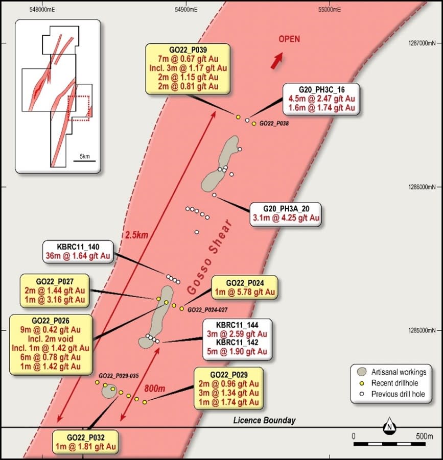
Figure 5: Plan showing Gosso target drilling locations and results
At Kobada East, two fences of RC drilling were completed across an auger anomaly defined during a regional programme in 20225. High grade results were previously received from the Kobada East target (earlier denoted as Target E), including:
20.69 g/t Au over 8.0 m from 2.0 m to 10.0 m (Auger hole E-423)
including 78.9 g/t Au over 2.0 m
including 3.14 g/t Au over 2.0 m
1.81 g/t Au over 8.0 m from 10.0 m to 18.0 m (Auger hole E-412)
including 3.94 g/t Au over 2.0 m
2.42 g/t Au over 2.0 m from 0.0 m to 2.0 m (Drill hole E-417)
Drilling at Kobada East was carried out on sections spaced 400 metres apart within the 800m long anomaly as shown on Figure 6. Results are detailed in the ASX Announcement of 26 April 2023 and include:
6m at 0.85g/t from 79m incl. 2m at 1.70g/t (KE22_P013 – southern section)
1m at 3.58g/t from 9m (KE22_P007 – northern section)
1m at 3.35g/t from 26m (KE22_P008 – northern section)
4m at 0.41g/t from 86m (KE22_P006 – northern section)
Confirmation of sub surface mineralisation at Kobada East, below the auger anomalism, is a significant milestone. The tenor of mineralisation indicates that a continuous mineralised system is present at Kobada East, with similar results documented from early drill programs at the Kobada Main deposit. All intersections reported occur in oxide mineralisation, improving the viability of the mineralisation.

Figure 6: Plan showing Kobada East (Target E) RC and auger drilling locations and results
At Kobada South, three fences of drilling were completed. The most southerly of these stepped out 250 metres south from the last fence of drilling within the Kobada Main resource and successfully intersected mineralisation, including:
3m at 1.81g/t from 50m and 3m at 1.20g/t from 61m (KS22_P003)
Drilling was also carried out to infill a 500m gap in drilling at the southern end of the Mineral Resource with results to inform a resource update planned for later in 2023. Key results included:
1m at 8.35g/t from 68m (KS22_P012) and 3m at 1.80g/t from 82m (KS22_P014)
In addition, drilling was completed to test extensions to mineralisation on a parallel lode to the Kobada Main lode. Intersections of 2m at 0.75g/t from 6m and 4m at 0.52g/t from 40m (KS22_P025) were returned, demonstrating continuity of mineralisation on this eastern lode for a further 200m. Further work is planned in future programs to test the potential of this parallel lode.
All results are shown on Figure 7 and detailed in the ASX Announcement of 8 March 2023.
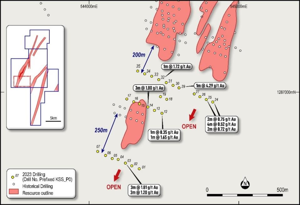
Figure 7: Kobada South target showing Toubani drilling locations and results
This announcement has been authorised for release by the Board of Toubani Resources.
Phil Russo | Jane Morgan |
Chief Executive Officer and Executive Director | Investor and Media Relations |
+61 (0) 478 138 627 | +61 (0) 405 555 618 |
About Toubani Resources Inc
Toubani Resources (ASX: TRE) is an exploration and development Company with a focus on becoming Africa’s next gold producer with its advanced Kobada Gold Project. The Company has a highly experienced Board and management team with a proven African track record in advancing projects through exploration, development and into production.
For more information regarding Toubani Resources visit our website at www.toubaniresources.com.
Competent Person’s Statement
The information in this press release relating to geology and Exploration Results is based on information compiled, reviewed and assessed by Mr. Bill Oliver, who is a Member of the Australasian Institute of Mining and Metallurgy and the Australian Institute of Geoscientists. Mr. Oliver is a consultant to the Company and has sufficient experience which is relevant to the style of mineralisation and type of deposit under consideration and to the activity which he is undertaking to qualify as a Competent Person as defined by the 2012 Edition of the Australasian Code for reporting of Exploration Results, Mineral Resources and Ore Reserves (JORC Code). Mr. Oliver consents to the inclusion of the information in the form and context in which it appears.
The information in this press release relating to the Mineral Resources at the Kobada Deposit is extracted from Company's prospectus dated 12 September 2022 and released on ASX on 25 November 2022 (Prospectus) which is available on the ASX announcements platform. The Company confirms that it is not aware of any new information or data that materially affects the information relating to the Mineral Resources at the Kobada Deposit included in the Prospectus and all material assumptions and technical parameters underpinning the Mineral Resources estimate in the Prospectus continue to apply and have not materially changed.
Cautionary statements
This press release contains “forward-looking information” within the meaning of applicable Canadian securities legislation. Forward-looking information includes, but is not limited to, statements regarding the expansion of mineral resources and reserves, and drilling and exploration plans of the Company. Generally, forward-looking information can be identified by the use of forward-looking terminology such as “plans”, “expects” or “does not expect”, “is expected”, “budget”, “scheduled”, “estimates”, “forecasts”, “intends”, “anticipates” or “does not anticipate”, or “believes”, or variations of such words and phrases or statements that certain actions, events or results “may”, “could”, “would”, “might” or “will be taken”, “occur” or “be achieved”. Forward-looking information is subject to known and unknown risks, uncertainties and other factors that may cause the actual results, level of activity, performance or achievements of the Company to be materially different from those expressed or implied by such forward-looking information, including but not limited to: receipt of necessary approvals from Canadian and Australian regulatory authorities; general business, economic, competitive, political and social uncertainties; future prices of mineral prices; accidents, labour disputes and shortages; available infrastructure and supplies; the COVID-19 pandemic and other risks of the mining industry. Although the Company has attempted to identify important factors that could cause actual results to differ materially from those contained in forward-looking information, there may be other factors that cause results not to be as anticipated, estimated or intended. There can be no assurance that such information will prove to be accurate, as actual results and future events could differ materially from those anticipated in such statements. Accordingly, readers should not place undue reliance on forward-looking information. The Company does not undertake to update any forward-looking information, except in accordance with applicable securities laws.
Appendix 1. Kobada RC Drilling Data and Results
Hole ID | Target | Easting | Northing | RL | Dip | Azi | Depth | From | To | Length | Au |
KN22-P001 | Kobada | 548,070 | 1,293,721 | 378 | 55 | 295 | 140 | 63 | 64 | 1 | 0.44 |
KN22-P002 | Kobada | 548,020 | 1,293,740 | 372 | 55 | 295 | 140 | 95 | 98 | 3 | 0.36 |
KN22-P003 | Kobada | 548,005 | 1,293,306 | 391 | 55 | 295 | 140 | 82 | 83 | 1 | 9.62 |
|
|
|
|
|
|
|
| 134 | 136 | 2 | 3.38 |
KN22-P004 | Kobada | 547,963 | 1,293,327 | 384 | 55 | 295 | 140 | 53 | 54 | 1 | 0.39 |
KN22-P006 | Kobada | 547,859 | 1,293,365 | 388 | 55 | 295 | 140 |
| NSI |
|
|
KN22-P007 | Kobada | 547,819 | 1,293,390 | 385 | 55 | 295 | 140 | 24 | 25 | 1 | 0.65 |
|
|
|
|
|
|
|
| 119 | 120 | 1 | 6.09 |
|
|
|
|
|
|
|
| 125 | 126 | 1 | 0.44 |
KN22-P008 | Kobada | 547,809 | 1,292,744 | 394 | 55 | 295 | 140 | 30 | 33 | 3 | 0.31 |
|
|
|
|
|
|
|
| 68 | 69 | 1 | 0.43 |
|
|
|
|
|
|
|
| 139 | 140* | 1 | 1.41 |
KN22-P010 | Junction | 547,689 | 1,292,795 | 399 | 55 | 295 | 140 | 6 | 7 | 1 | 0.46 |
|
|
|
|
|
|
|
| 101 | 102 | 1 | 0.37 |
KN22-P011 | Junction | 547,630 | 1,292,820 | 394 | 55 | 295 | 140 |
| NSI |
|
|
KN22-P012 | Junction | 547,575 | 1,292,840 | 399 | 55 | 295 | 140 | 9 | 10 | 1 | 0.38 |
|
|
|
|
|
|
|
| 133 | 140* | 7 | 0.70 |
|
|
|
|
|
|
| incl. | 134 | 137 | 3 | 1.21 |
KN22-P013 | Junction | 547,519 | 1,292,862 | 389 | 55 | 295 | 140 | 51 | 52 | 1 | 0.59 |
|
|
|
|
|
|
|
| 57 | 58 | 1 | 0.95 |
KN22-P014 | Junction | 547,461 | 1,292,883 | 398 | 55 | 295 | 140 | 41 | 43 | 2 | 0.42 |
|
|
|
|
|
|
|
| 52 | 53 | 1 | 0.32 |
|
|
|
|
|
|
|
| 59 | 60 | 1 | 24.8 |
|
|
|
|
|
|
|
| 63 | 64 | 1 | 0.47 |
KN22-P015 | Junction | 547,409 | 1,292,904 | 386 | 55 | 295 | 140 |
| NSI |
|
|
KN22-P016 | Junction | 547,350 | 1,292,922 | 390 | 55 | 295 | 140 |
| NSI |
|
|
KN22-P017 | Junction | 547,295 | 1,292,958 | 389 | 55 | 295 | 140 |
| NSI |
|
|
KN22-P021 | Junction | 547,577 | 1,292,407 | 389 | 55 | 295 | 140 | 68 | 69 | 1 | 0.33 |
KN22-P022 | Junction | 547,527 | 1,292,433 | 393 | 55 | 295 | 140 |
| NSI |
|
|
KN22-P025 | Junction | 547,353 | 1,292,495 | 378 | 55 | 295 | 140 | 0 | 1 | 1 | 1.35 |
KN22-P026 | Junction | 547,303 | 1,292,526 | 392 | 55 | 295 | 140 | 115 | 116 | 1 | 1.00 |
KN22-P027 | Junction | 547,242 | 1,292,547 | 373 | 55 | 295 | 140 |
| NSI |
|
|
KN22-P028 | Junction | 547,196 | 1,292,575 | 366 | 55 | 295 | 140 |
| NSI |
|
|
KN22-P029 | Junction | 547,143 | 1,292,593 | 374 | 55 | 295 | 140 |
| NSI |
|
|
KN22-P030 | Foroko | 547,654 | 1,291,293 | 370 | 55 | 295 | 120 |
| NSI |
|
|
KN22-P031 | Foroko | 547,720 | 1,291,309 | 373 | 55 | 295 | 120 |
| NSI |
|
|
KN22-P032 | Foroko | 547,778 | 1,291,308 | 384 | 55 | 295 | 120 |
| NSI |
|
|
NSI – No Significant Intersection
* denotes sample at end of hole
Appendix 2. The following tables are provided to ensure compliance with JORC Code requirements for the reporting of Exploration Results from the Kobada Project
Section 1 Sampling Techniques and Data
(Criteria in this section apply to all succeeding sections.)
Criteria | JORC Code explanation | Commentary |
Sampling techniques |
| Drilling samples collected using reverse circulation (RC) percussion drilling. |
Drilling techniques |
| Reverse Circulation drilling using 127mm face sampling hammer |
Drill sample recovery |
| RC samples are weighed to quantify recovery. |
Logging |
| Geological logging of RC drilling is completed to an acceptable standard for use in Mineral Resource estimation. |
Sub-sampling techniques and sample preparation |
| All RC samples are split using a riffle splitter with one split (approximately 1 to 2 kg) collected for laboratory testing and the remaining amount after splitting is retained in the bulk bag for future reference. All samples were sampled dry. |
Quality of assay data and laboratory tests |
| Samples were submitted to the SANAS and ISO/IEC 17025 accredited SGS Laboratory in Bamako. Samples were tested by fire assay with an AAS finish. Samples < 3.0 kg were dried in trays, crushed to a nominal 2 mm using a jaw crusher, and then < 1.5 kg were split using a Jones-type riffle splitter. Reject sample was retained in the original bag and stored. The sample was pulverised in an LM2 pulveriser to a nominal 85 % passing 75 µm. An approximately 200 g subsample was taken for assay, with the pulverised residue retained in a plastic bag. All the preparation equipment was flushed with barren material prior to the commencement of the job. A 50 g subsample was fused with a litharge-based flux, cupelled, and the prill is dissolved in aqua regia, and gold is determined by flame AAS (Detection Limit 0.01 ppm). |
Verification of sampling and assaying |
| Significant intersections have been estimated by consultants to the company and cross checked. |
Location of data points |
| The drillhole collars have been located with a Garmin handheld GPS with a ± 5 m accuracy |
Data spacing and distribution |
| Drillholes are being drilled at spacings between 50 and 100m on section, with sections 200 – 400 metres apart. |
Orientation of data in relation to geological structure |
| Drilling orientation is planned perpendicular to the regional structural trend (NNE). |
Sample security | The measures taken to ensure sample security. | Industry best practice has been applied to the drilling sampling processes carried out. Drilled samples were transported in a manner to prevent loss or cross-contamination. All samples were stored in a secure storage facility pending dispatch to laboratory in Bamako. In line with protocol, two people were used to transport the samples directly to the laboratory. Once at the laboratory, the samples were subject to the standard security measures of the laboratory. |
Audits or reviews |
| No audits have been completed. |
Section 2 Reporting of Exploration Results
(Criteria in this section apply to all succeeding sections.)
Criteria | JORC Code explanation | Commentary |
Mineral tenement and land tenure status |
| African Gold Group Mali SARL, a wholly-owned subsidiary of TRE, holds a mining permit No. PE 15/22 encompassing an area of 135.7 km² for the Kobada project area valid to 30 July 2045. Two adjacent exploration permits are also held, namely Kobada-Est (No. PR 18/957 over 77 km² valid to 15 August 2024 for three years) and Faraba (for which renewal was granted under Arrêté No. 2021-3226/MMP-SG effective 6 April 2021 for a further three years. |
Exploration done by other parties |
| Bureau de Recherches Géologiques et Minières conducted historical exploration in 1982 to 1988, which respectively identified and delineated the Kobada Shear Zone through geochemistry surveys and latter diamond drilling. La Source undertook RC drilling in 1996, followed in 2002 and 2004 respectively by RC and air core drilling by Cominor. IAMGold completed diamond and RC drilling in 2009. |
Geology |
| The Project is located in the Bagoe Formation on the north-central edge of the Birimian rock units that form part of the Leo Rise in the southern part of the West African Craton. The Project is situated on the western flank of the Bougouni Basin, composed primarily of sedimentary rocks with minor tholeiitic volcano-sedimentary intercalations. |
Drill hole Information |
| Refer Appendix 1. |
Data aggregation methods |
| Averaging is weighted based on length, with all samples 1m in downhole length. |
Relationship between mineralisation widths and intercept lengths |
| Downhole lengths are presented in Appendix 1. True widths have not been calculated. |
Diagrams |
| • Refer to figures within this report. |
Balanced reporting |
| All meaningful information has been included in the body of the text and all results are presented in Appendix 1. |
Other substantive exploration data |
| All material data and information is detailed in the Company's prospectus dated 12 September 2022 and released on ASX on 25 November 2022. |
Further work |
| As detailed in the text – drilling is ongoing at the project and further drilling will be planned to follow up these results. |
_______________________________
1 Combined Measured, Indicated and Inferred Mineral Resource of 103.57Mt at 0.94g/t.
Refer to the Company's prospectus dated 12 September 2022 and released on ASX on 25 November 2022
2 “Extension to Mineralisation” is based on strike length of mineralisation defined by drilling and measured from last historical drill result to furthest new intersection along strike. Where no historical drilling has occurred the measurement is of strike extent defined by Toubani’s drilling in this program.
3 Refer ASX Announcement 31 May 2023
4 Refer to the Company's prospectus dated 12 September 2022 and released on ASX on 25 November 2022
5 Refer “Auger Drilling Confirms Further Gold Mineralization on the Kobada Est Permit”, published 2nd August 2022
Figures accompanying this announcement are available at
https://www.globenewswire.com/NewsRoom/AttachmentNg/ffd41c05-d862-432c-8c7c-9163fd168066
https://www.globenewswire.com/NewsRoom/AttachmentNg/bb613924-50c4-433d-b873-5f23a90f2e12
https://www.globenewswire.com/NewsRoom/AttachmentNg/414d3ea8-8b8f-44c6-9134-e54546dda40d
https://www.globenewswire.com/NewsRoom/AttachmentNg/e40fcd73-57ea-40d6-be11-baba2a6345df
https://www.globenewswire.com/NewsRoom/AttachmentNg/536cbec1-c0a6-4cea-bc0a-a7d03524eb12
https://www.globenewswire.com/NewsRoom/AttachmentNg/c944aa89-ac53-40a4-a9d9-1df2160476e0
https://www.globenewswire.com/NewsRoom/AttachmentNg/67f44adc-4810-4f60-b62b-e391471af46e

